

German-Israeli Tell Iẓṭabba Excavation Project (GITIEP)
General outline & Introduction
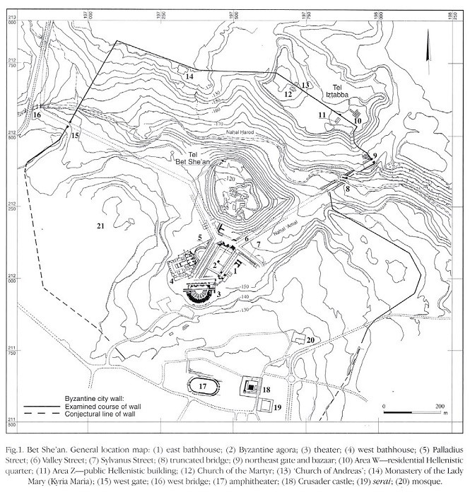
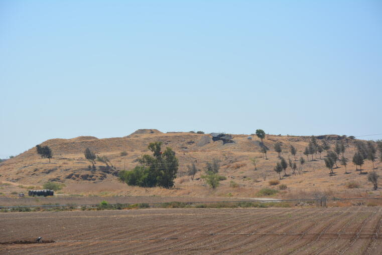
Our Archaeological Project “ Tell Iẓṭabba (Nysa-Skythopolis) – eine seleukidische Gründung im Nahen Osten/Tell Iẓṭabba (Nysa-Skythopolis) - a Seleucid Foundation in the Near East ” is a German-Israeli Archaeological Project funded by the Deutsche Forschungsgemeinschaft (DFG) and co-headed by Achim Lichtenberger of the Classical Archaeology Department of the University of Münster/Germany and Oren Tal of the Sonia and Marco Nadler Institute for Archaeology at the Tel Aviv University/Israel. The dig takes place on Tell Iẓṭabba (East), which is a mound (tell) in the northern part of the ancient city of Nysa-Scythopolis (fig. 1), biblical and modern Beth Shean, in the northern Jordan valley in Israel. Beth Shean was re-founded as Scythopolis on the biblical Tell Beth Shean, in the third century BCE under Ptolemy II Soter, but during the Fifth Syrian War (202–195 BCE) the entire region was conquered by the rivalling kingdom of the Seleucids of Syria. The Hellenistic town was re-founded on Tell Iẓṭabba by Antiochos IV as Nysa. This is confirmed by the analysis of coins and stamped Rhodian Amphora handles. The town did not exist for a long time; the conflicts between the Seleucids and the rising power of the Hasmoneans of Judea bring to an abrupt and violent end to the Seleucid-funded town on Tell Iẓṭabba in 108/07 BCE by John Hyrcanus who conquered and destroyed the town and sent its inhabitants into exile. Only under Pompey the Great in the first half of the 1st century was the city rebuilt. However, the majority of the Roman-period city was excavated in the area stretching south of the foot of biblical Tell Beth Shean. Scythopolis now was a thriving city of the Decapolis. At present, no excavation on Tell Iẓṭabba brought any extensive Roman remains to light. Only in the 5th and 6th centuries CE, during Christian-Byzantine rule, were three churches and adjacent structures built on Tell Iẓṭabba, as well as the Byzantine-period city wall.
History of research at Tell Iẓṭabba
The first modern excavations in Beth Shean were conducted on behalf of the Museum of Philadelphia during the late 20s/early 30s of the 20th century by C. Fischer, G. M. FitzGerald and A. Rowe (FitzGerald 1939), with excavations being carried out in different locations. On top of the biblical tell they revealed a monumental, circular-shaped church, underneath Early Islamic remains. They have also recorded Hellenistic-Roman, Iron Age and Bronze Age period remains. Their excavation activity on Tell Iẓṭabba (West) unearthed an ancient monastic complex inside the Byzantine city, dubbed the Kyria Maria Monastery. Just underneath it, an ancient necropolis was discovered on the steep slopes of Tell Iẓṭabba, which was then extensively excavated under the name ‘the Northern Cemetery’ (Oren 1973).
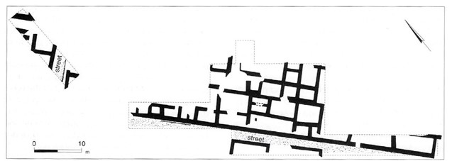
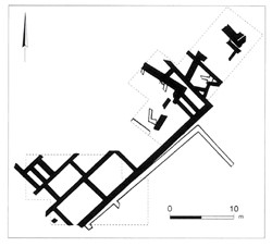
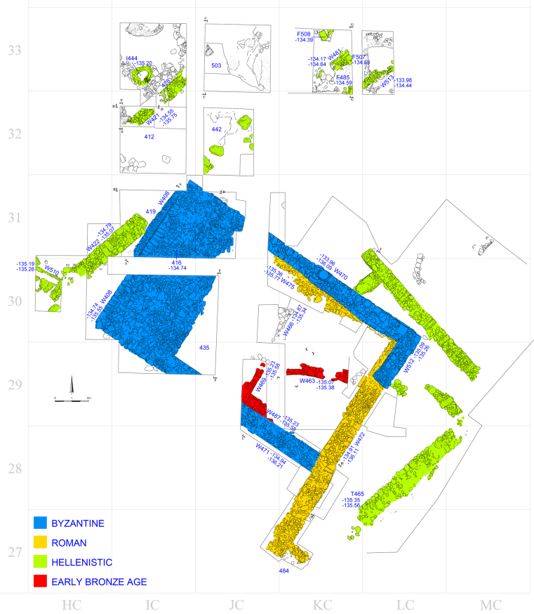
The next excavation was conducted by N. Zori on behalf of the Department of Antiquities and Museums of the State of Israel, on the eastern part of Tell Iẓṭabba, following the installation of a water pipe (Zori 1962). He recorded extensive Hellenistic remains, including stamped Rhodian Amphora handles. Another small salvage excavation was conducted by V. Tzaferis on behalf of the Israel Antiquities Authority on the eastern part of the tell (Landau and Tzaferis 1979). Tzaferis found structures which he interpreted as a Byzantine-period public building, making use of Hellenistic architectural decoration. He also found numerous stamped Rhodian Amphora-handles in Hellenistic layers. In the context of the ‘Bet Shean Excavation Project’ (Excavations and Surveys in Israel 17 [1998]), a team led by G. Mazor and R. Bar-Nathan from the Israel Antiquities Authority excavated at Tell Iẓṭabba (East), while other teams worked in other parts of the ancient city of Beth Shean. The multi-year excavation program during the early 90s have uncovered several structures. On Tell Iẓṭabba (East), Mazor and Bar-Nathan cleared the 5th century CE City wall and two Byzantine Churches (the Church of the Martyr and the Church of Andreas), as well as Hellenistic period remains. Extensive Hellenistic remains were encountered in two areas, W and Z. In Area W (figs. 2, 4), a residential quarter was unearthed. Its full plan could not be clarified, but it seemed to be an insula, surrounded by streets, leading to the assumption that the city was organized by an orthogonal street system and habitation in insula-like quarters. Area Z (fig. 3) lies close to the southern slope of the tell, flanking the previous excavations of Tzaferis. The walls were re-interpreted as part of a Roman public building, making use of earlier, Hellenistic architectural elements, such as fragmented columns and ionic capitals. In numerous places, Early Bronze Age material and walls were recorded underneath the Hellenistic layers, but these were disturbed by the later settlement activity. Smaller areas were opened at other parts of the mound and added further information on the extent of the Hellenistic settlement (fig. 5). In Area H, a structure built of a basalt foundation and upper courses of limestone, was interpreted as a Hellenistic corner-tower within the town wall, while in the much smaller areas (M and T) on the western spur of Tell Iẓṭabba (East), further evidence of the site’s Hellenistic occupation were brought to light.
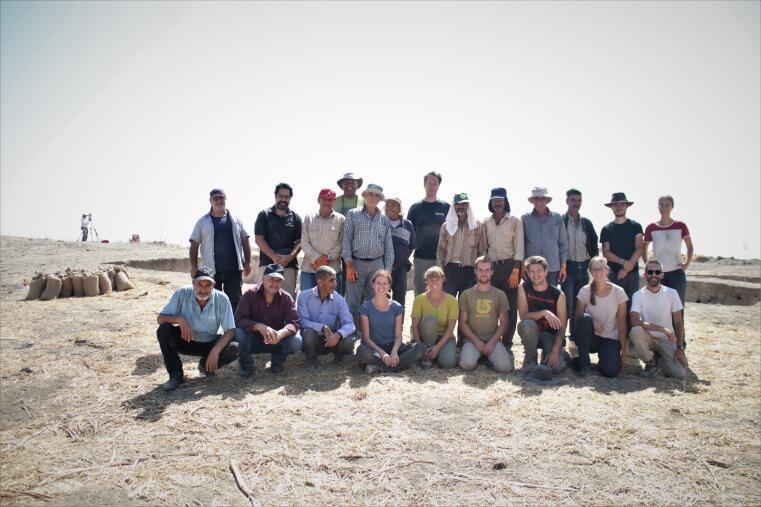
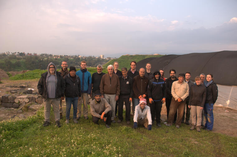
Our team
Directors:
Prof. Dr. Achim Lichtenberger, University of Münster
https://www.uni-muenster.de/Archaeologie/personen/lichtenberger/index.html
Prof. Oren Tal, Tel Aviv University
https://english.tau.ac.il/profile/orental
Staff:
Dr. Meir Edrey, University of Haifa
https://maritime.haifa.ac.il/dr-meir-edrey/
Philip Ebeling, MA, University of Münster
https://www.uni-muenster.de/Archaeologie/personen/ebeling.html
Tamar Harpak, BA, Israel Antiquities Authority
Jessica Schellig, MA, University of Münster
Hagi Yohanan, MA, Independent Scholar
Find analysis:
Dr. Donald Ariel, Israel Antiquities Authority, stamped amphorae handles
Dr. Dana Ashkenazi, Tel Aviv University, finds chemical analyses
Dr. Anat Cohen-Weinberger, Israel Antiquities Authority, petrographic analysis
Dr. Ruth Jackson-Tal, Israel Museum, Jerusalem, glass and faience finds
Prof. Dr. Sabine Klein, Deutsches Bergbaumuseum, archaeometallurgical analysis
Dr. Marta Lorenzon, University of Helsinki, mudbrick analysis
Henk Mienis/Oz Ritner, Tel Aviv University, molluscs
Dr. Yossi Nagar, Israel Antiquities Authority, skeletal remains
Dr. Andrea Orendi, ArchaeoConnect, Tübingen, archaeobotany
Manuel J. H. Peters, Max Planck Institute for Geoanthropology, Jena, GIS
Miriam Pines, MA, Tel Aviv University, archaeozoology
Prof. Dr. Silvia Polla, Freie Universität Berlin, residue analysis
Dr. Marcio Teixeira Bastos, São Paulo, Lychnology
Our goals
We are concerned with the Seleucid re-foundation of Beth Shean-Nysa. In many of the cities of the Decapolis, hardly any Hellenistic remains were unearthed. Only in Gerasa, Gadara and Beth Shean were noteworthy Hellenistic period remains found. However, in the cases of Gerasa and Gadara, the Hellenistic period foundations were subsequently overbuilt by Roman, Byzantine and Early Umayyad period structures. This is not the case on Tell Iẓṭabba, where the Seleucid occupation phase is well preserved because of selective post-Hellenistic re-occupation. Such a fortunate setting to investigate the Hellenistic period in a Decapolis city is unique. The main aim of the German-Israeli project is to increase our understanding of Hellenistic settlements in the region. More specifically, it is assumed that early Seleucid foundations were military in character. Such a claim was never successfully tested on archaeological evidence. We also want to clarify the urban layout of Nysa in terms of its general infrastructure, water management, and public and private organisation of life; the former attests to potential Hellenistic period monumental and architectural decoration. In addition to that, we are studying the dietary habits of the Hellenistic sites’ inhabitants by archaeozoological, archaeobotanical and residue analysis studies.
Our February 2019 campaign
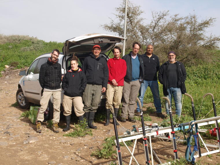
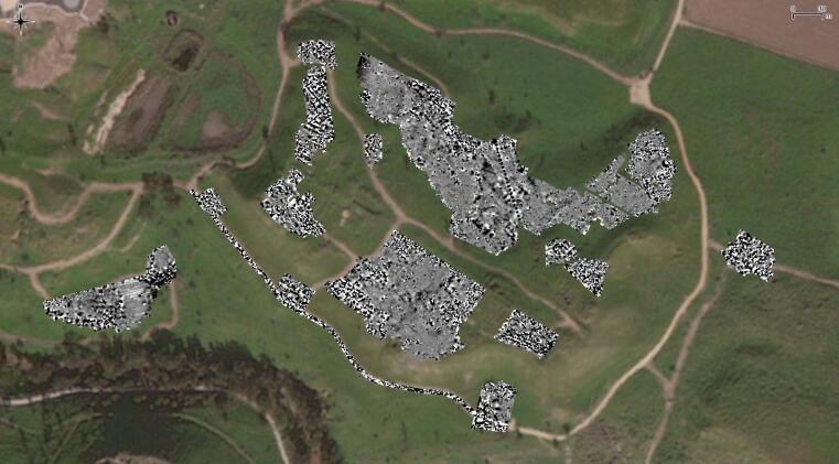
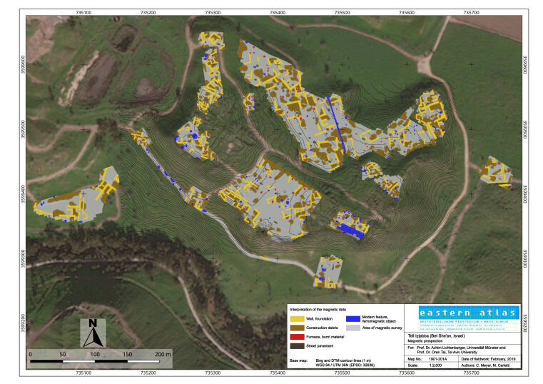
Our first systematic field campaign included a magnetic prospection of Tell Iẓṭabba (East). It was carried out by the Berlin-based company Eastern Atlas (http://www.eastern-atlas.de/start/index_ger.php). In total 12ha were surveyed. For the magnetic measurements, an array of seven Förster fluxgate gradiometer probes was used. The gradiometer array is a component of the convertible LEA MAX system. The interpretation of the results can be seen in fig. 7, where yellow indicates walls, brown refers to construction debris, red foe fired material, like oven or heaps of pottery, and blue attests to modern features, like metallic pipes or other anomalies. This interpreted map suggests large structures in all the tell levels, with open spaces, as well. Up to now, it is not possible from this map to safely attribute any of the features to certain building periods. Archaeological investigation will clarify any further assumptions. The results of our magnetic prospection are to be published soon (Lichtenberger, Meyer and Tal 2020), and our magnetic data is currently published as open data on figshare (https://doi.org/10.6084/m9.figshare.12014514).
Our September 2019 campaign
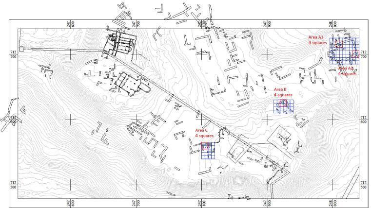
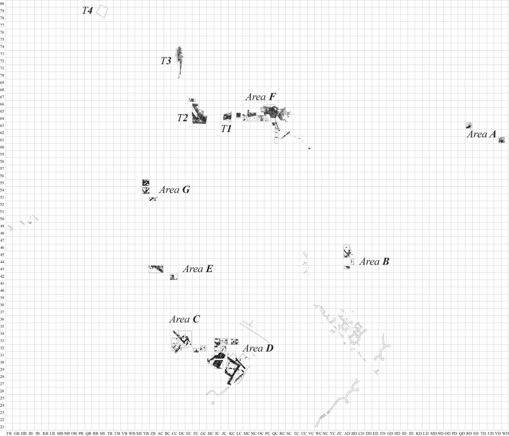
In our second systematic field campaign, excavations were begun. We chose three areas (A, B and C) to be opened (fig. 8). Area A was chosen to investigate the tells’ northeastern edge in search of further fortifications, such as those previously found by the Israel Antiquities Authority in Area H. It was separated into two smaller areas (A1 and A2), as we wanted to track the assumed fortification line on north and on east (fig. 9). In Area A1 we have unearthed a Byzantine period domestic structure, built of basalt stones, with a floor of mud and a basalt stone-built chest underneath, containing a glass vessel, as a foundation deposit. In Area A2, we have uncovered a rock-cut tomb (that we left unopened) and other installations spanning the Bronze Age to the Byzantine/Early Islamic period.
In Area B (fig. 10), which is located in close proximity to the previously excavated Israel Antiquities Authority’s Area W, we found structures of a domestic nature, dated to the Hellenistic period, that were violently destroyed by fire. The basalt fieldstones foundation walls were preserved up to ca. 50cm above floor level and doorways between rooms were enhanced by large, rectangular-shaped limestone blocks, set up right (orthostates) (fig. 11). A sewer channel, without its stone cover preserved, running underneath the structure, was dug on north; and a part of a courtyard, with a round oven installed on a floor, paved with basalt slabs, was dug on south. Off-situ, painted Hellenistic plaster stucco, as well as table, cooking and storage wares (including stamped Rhodian amphorae handles), lamps and coins came from this area.
In Area C (fig. 12), which is located some 50m west of the previously excavated Israel Antiquities Authority’s Area Z, excavations unearthed an additional structure, also domestic in nature, similarly built and designed to those of Area B. One of the structures preserved three rooms, whose floors showed a destruction level with many pottery vessels which included, among other wares, Rhodian and Knidian amphorae.

Our February 2020 campaign
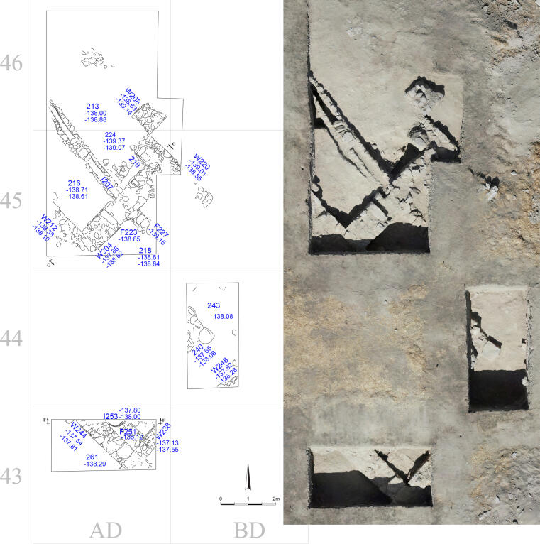
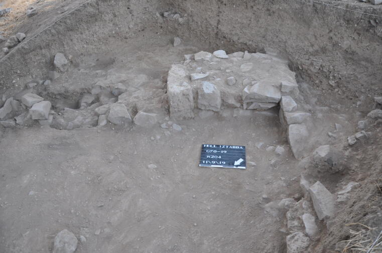
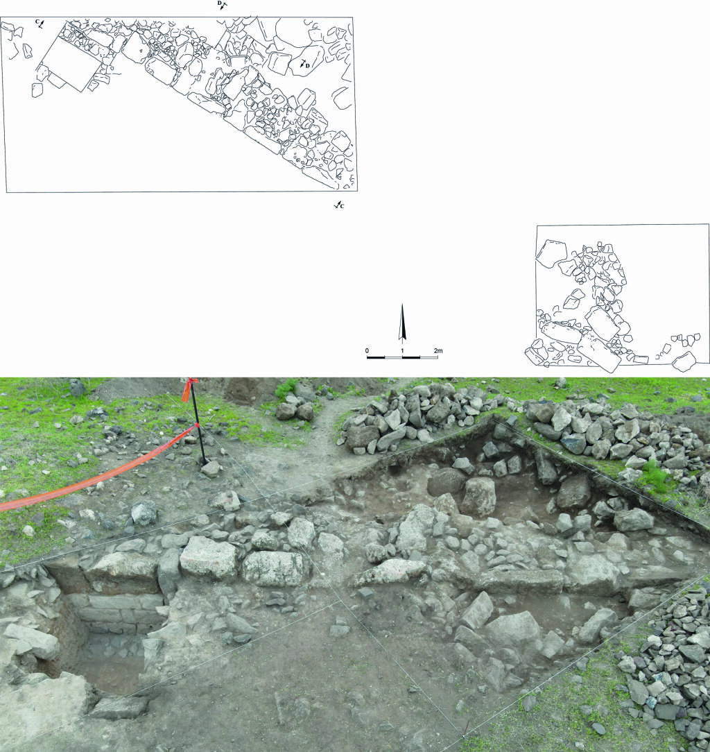
Our third systematic field campaign was mostly dedicated to a newly opened area, Area D (fig. 14), located between our Area C and the Israel Antiquities Authority’s Area Z. Here, we have exposed a monumental structure of dressed basalt stones, in an ENE–WSW orientation, featuring a monumental ‘podium’ at its western end. While the analysis of this structure is still undergoing, its building orientation may attest to its connection to the Byzantine city wall. Its interpretation is still under discussion but it seems to be built on an earlier, similarly oriented structure (fig. 15).
The northern-wall of this ‘podium-building’ incorporates the previously exposed elements of architectural decoration, as reported in the Tzaferis excavation. During our dig, we have managed to uncover this wall to its full length and those areas that flank it to the east and west. Among the features excavated, mudbrick walls of the Early Bronze Age were also recovered.
The ‘podium-building’ was built upon earlier walls of the Hellenistic period that have incorporated sizable mudbricks, similar in shape and size to those limestone orthostates we have uncovered in Areas B and C. The building technique of the ‘podium-building’ with its spolia in the walls is unique at Tell Iẓṭabba and its environs. Further investigation is necessary in this area to better understand its stratigraphy and architecture. Finds of the last season were predominantly Hellenistic, but Early Bronze Age pottery was recovered, as well.
Our February 2023 campaign
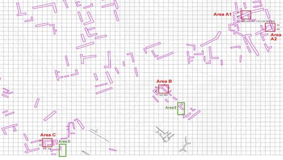
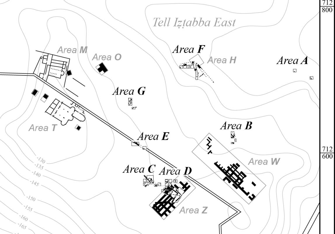
Our fourth systematic field campaign focused on three new areas (Area E, F and G, fig. 17). Area E was located at the Byzantine city wall (fig. 18 up and down). This wall was investigated at this particular spot for several large limestone blocks, densely reused in the investigated stretch of wall, which is everywhere else constructed almost entirely of basalt blocks. The limestone blocks must have been from an earlier, monumental structure close to it. However, the wall was found to be built on a layer of flat stones, which was laid upon a simple soil fill. The ancient walk-on level was higher on the southern side (intra muros), than on the northern (extra muros), by evidence of the wall collapse.
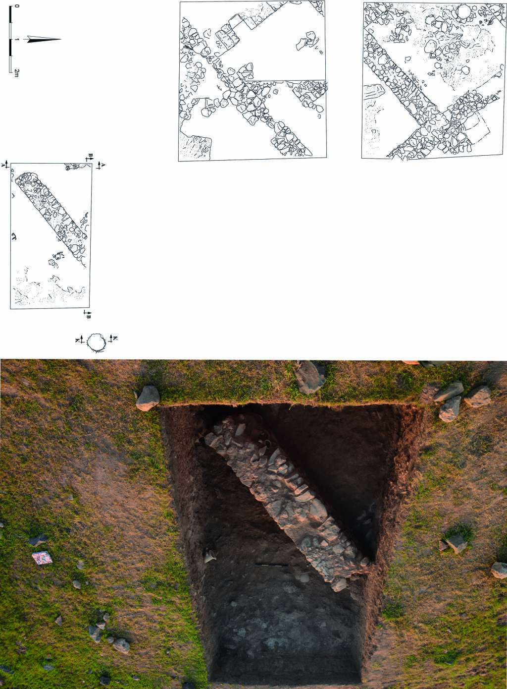
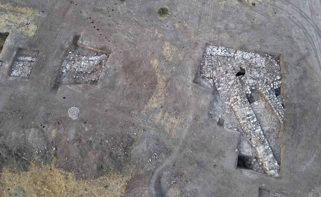
In Area F, located at the northern edge of the lower plateau, covered the largest excavated area (fig. 19 up). It was located adjacent to the Area H of the Israel Antiquities Authority-excavation of the 1990ies, in which the structures discovered were preliminarily published as the Hellenistic city wall. The squares of Area F revealed the remains of a monumental coffer-style wall, in which intersecting mudbricks separated packages of roughly dressed basalt field stones (fig. 20). It was, thus, differing intensively in style and construction from the remains in the IAA’s Area H just adjacent to it. The wall in Area F, however, was tentatively identified as the Hellenistic city wall, challenging the interpretation of the structures, previously excavated by the IAA. This newly discovered coffer-style wall was erected on top of bedrock, which is of soft, yellow limestone. A pit was carved out of this limestone, just north of the coffer-style wall. A channel, into which pottery pipes were inserted, was seemingly leading water from outside the wall into the pit (fig. 19 down).
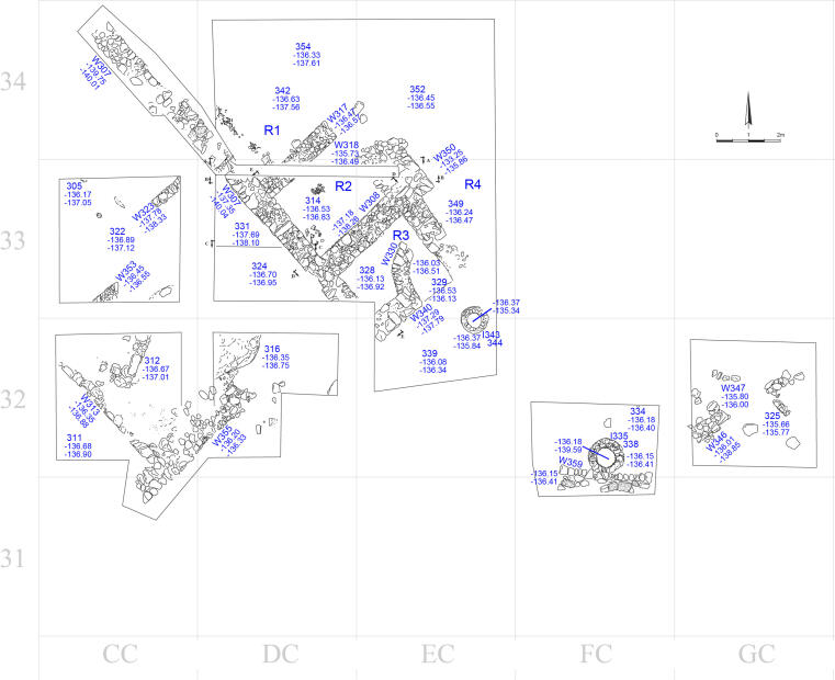
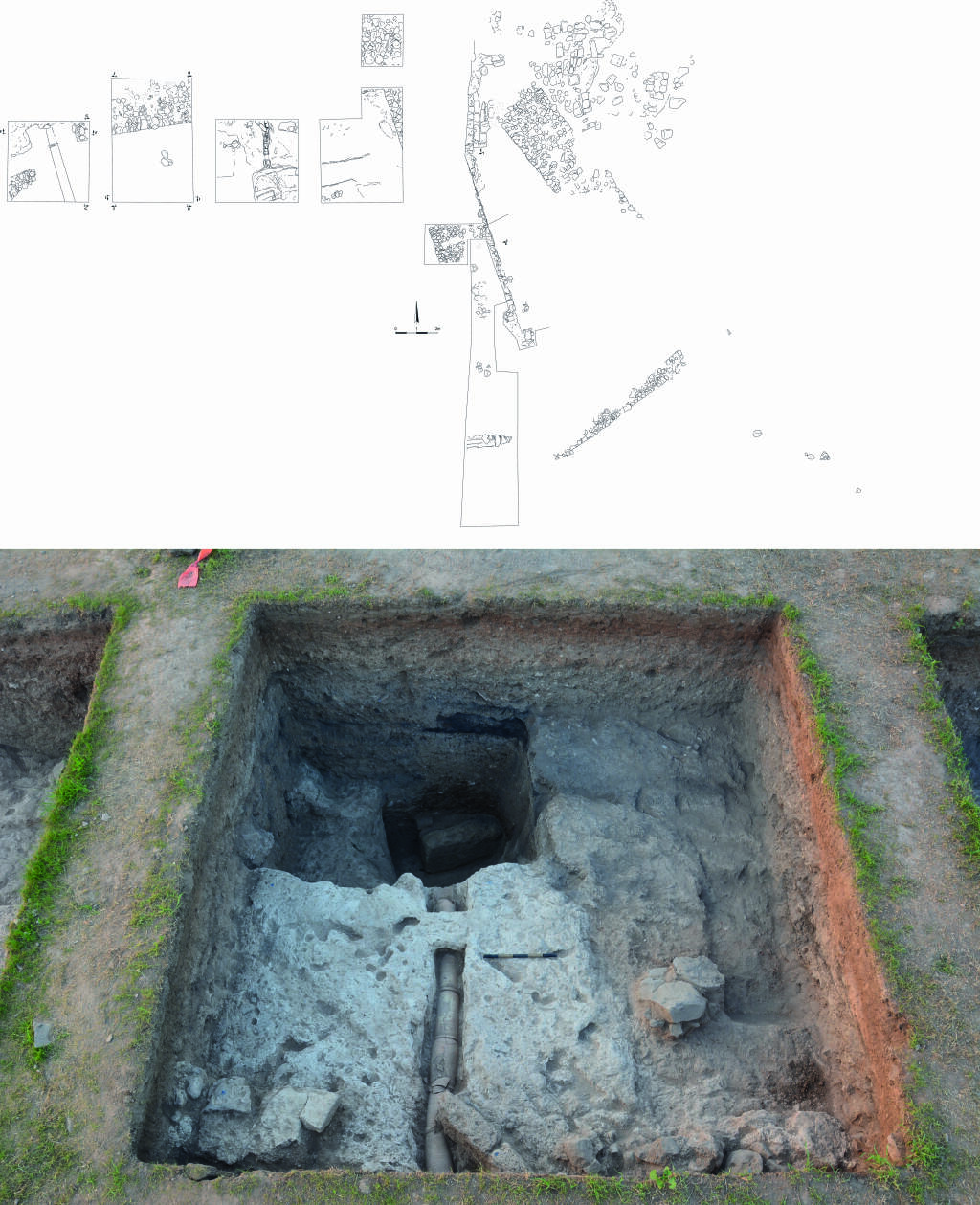
Area G was opened on top of an intermediary terrace, below the Byzantine period churches further to the south on the tell top, for a deep silo-style hole in the ground, which was either not noticed or not open in previous seasons (fig. 21). In Area G 2 ½ squares were opened and led to the discovery of well-preserved remains of domestic dwellings. Those remains consisted of several rooms and a plastered courtyard, in which a second silo was found. It was north of the previously mentioned silo and still closed by simple field stones. The connection of the firstly discovered, southern silo to the other domestic dwellings could not be clarified. The walls of those dwellings were consisted of a base, constructed of small- to medium-sized basalt field stones, with a mudbrick superstructure. The openings for the connection between rooms were lined up by a large, square mudbrick.
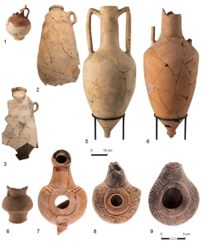
In both, Areas F and G, finds were well-preserved and numerous, including several intact lamps, one intact jug and a multitude of Amphoras (Rhodian and Knidian), next to bones (fig. 22). All of these finds were retrieved from within Area F as part of a thick, black, ashy layer in particular, and in Area G in the two rooms, west of the southern silo.
Our 2025 campaigns
The 2025 field season focused on the investigation of the northern fortifications of Nysa-Scythopolis. Fieldwork was conducted in two campaigns: a short survey and trial excavation in March 2025, followed by a full excavation season in September 2025.
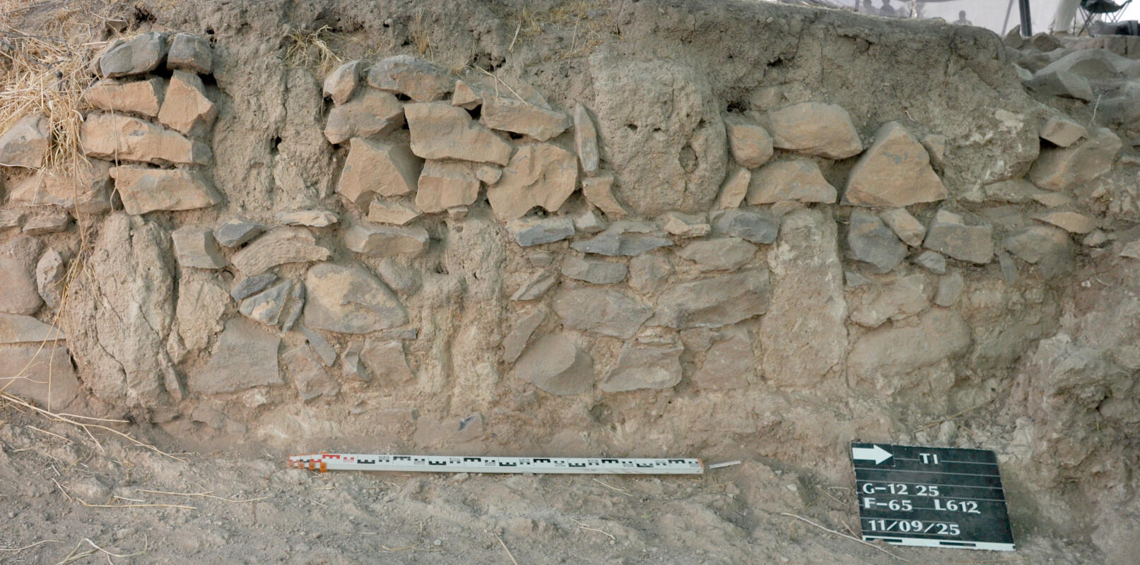
The main objective of the campaigns was to trace the course of the Seleucid city wall, to examine its construction technique, and to assess possible archaeological evidence for the Hasmonean conquest and destruction of the city in 107 BCE. Excavations concentrated on Area F, previously explored in 2023, and on four additional trenches (T1-T4) extending westward and northwestward along the northern edge of the mound (fig. 23).
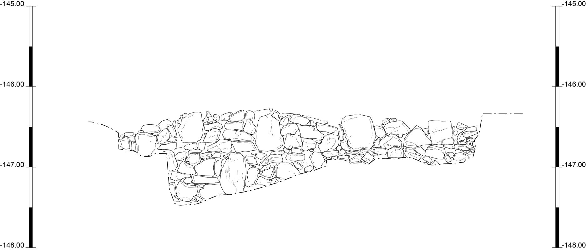
The 2025 excavations successfully identified and documented a massive fortification wall, approximately 2.70 m thick, which can now be traced for at least 125 m. The wall follows the natural ridge and shows an offset-inset layout. It was constructed using a distinctive “staggered-reinforcing-header” technique, combining large travertine orthostats with compartments filled with basalt fieldstones, laid without mortar (fig. 25). This construction method places the fortifications of Nysa-Scythopolis among the best-preserved and best-understood Seleucid city walls in the southern Levant.
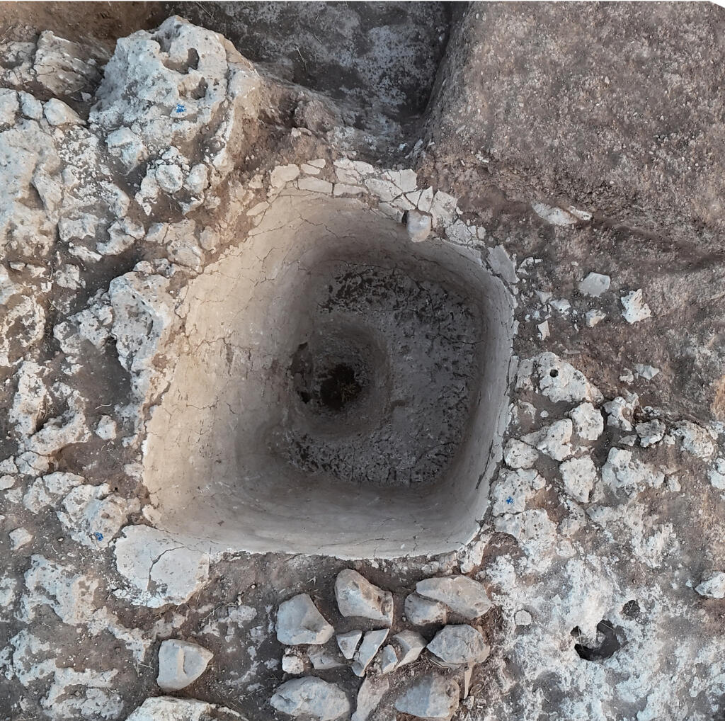
Beneath the fortifications in Area F, excavations revealed an earlier plastered industrial installation, most likely a Hellenistic winepress predating the construction of the city wall (fig. 26). This discovery indicates activity on the site before the foundation or fortification of the Seleucid city and adds an important new dimension to the settlement history of Tell Iztabba.
Finds from the 2025 season include predominantly Hellenistic pottery (with additional Byzantine material close to surface level), Rhodian stamped amphora handles, Seleucid coins, fragments of glass vessels, and a large number of sling bullets made of stone. The concentration of these bullets along the fortifications may be connected to the violent destruction of the city in 107 BCE.
Site-Related Bibliography (Current Excavations Studies)
Monographs
- Lichtenberger, A. and Tal, O. 2025. Hellenistic Nysa-Scythopolis I: The German-Israeli Tell Iẓṭabba Excavation Project. The 2019–2020 Seasons, Tel Aviv University, Monograph Series of the Institute of Archaeology 44 (University Park and Tel Aviv). [https://www.eisenbrauns.org/books/titles/978-1-64602-328-8.html]
Scholarly Articles
- Ariel, D. T. 2025. ‘Hellenistic Stamped Amphorae and Amphora Handles’, Pp. 239–264 in Lichtenberger, A. and Tal, O. (eds.), Hellenistic Nysa-Scythopolis I: The German-Israeli Tell Iẓṭabba Excavation Project. The 2019–2020 Seasons, Tel Aviv University, Monograph Series of the Institute of Archaeology 44 (University Park and Tel Aviv). [https://doi.org/10.1515/9781646023370-019]
- Ashkenazi, D., Shnabel, R., Lichtenberger, A. and Tal, O. 2021. ‘Chemical Composition and Microstructure Analysis of Plaster and Pigments Retrieved from a Decorated House Wall at Seleucid Tell Iẓṭabba (Nysa-Scythopolis, Beth She’an, Israel)’, Mediterranean Archaeology & Archaeometry 21/3: 89–122. [http://maajournal.com/Issues/2021/Vol21-3/6_Ashkenazi_et_al_21(3).pdf]
- Ashkenazi, D., Shnabel, R., Lichtenberger, A. and Tal, O. 2025. ‘Stucco Fragments and Their Chemical Analysis’, Pp. 199–224 in Lichtenberger, A. and Tal, O. (eds.), Hellenistic Nysa-Scythopolis I: The German-Israeli Tell Iẓṭabba Excavation Project. The 2019–2020 Seasons, Tel Aviv University, Monograph Series of the Institute of Archaeology 44 (University Park and Tel Aviv). [https://doi.org/10.1515/9781646023370-017]
-
Ashkenazi, D., Klein, S., Lichtenberger, A. and Tal, O. 2026. ‘Archaeometallurgical Characterization of Seleucid Leaded Bronze Coins: Towards an Understanding of Flans Standardization’, Metallography, Microstructructure, and Analysis 15(2). [https://doi.org/10.1007/s13632-026-01347-x]
- Atrash, W., Lichtenberger, A., Mazor, G., and Tal, O. 2020/2021. ‘Roman Ionic Capitals and Columns from the ‘Podium Building’ on Tell Iẓṭabba: Preliminary Notes on the Use of Spolia at Late Antique Beth She’an’, BOREAS: Münstersche Beiträge zur Archäologie 43/44: 91–104.
- Barford, G., Freestone, I.C., Jackson-Tal, R.E., Cruz-Uribe, A., Lichtenberger, A., and Tal, O. 2025. ‘The Hellenistic - Roman Transition in Glass Technology: Insights from Nysa-Scythopolis’, Heritage Science 13: 599. [https://www.nature.com/articles/s40494-025-02139-2]
- Ebeling, P. 2025. ‘Archival Archaeology: Beth-Shean in Philadelphia as a Test Case’, Pp. 37–64 in Lichtenberger, A. and Tal, O. (eds.), Hellenistic Nysa-Scythopolis I: The German-Israeli Tell Iẓṭabba Excavation Project. The 2019–2020 Seasons, Tel Aviv University, Monograph Series of the Institute of Archaeology 44 (University Park and Tel Aviv). [https://doi.org/10.1515/9781646023370-004]
- Ebeling, P., Edrey, M., Harpak, T., Lichtenberger, A. and Tal, O. 2020. ‘Field Report on the 2019 German-Israeli Tell Iẓṭabbā Excavation Project (Beth She’an), Israel’, Zeitschrift des Deutschen Palästina-Vereins 136/2: 176–190.
- Ebeling, P., Edrey, M., Harpak, T., Lichtenberger, A. and Tal, O. 2021. ‘Field Report on the 2020 German-Israeli Tell Iẓṭabbā Excavation Project (Beth She’an), Israel’, Zeitschrift des Deutschen Palästina-Vereins 137/1: 60–74.
- Ebeling, P., Harpak, T., Lichtenberger, A. and Tal, O. 2025. ‘Area B’, Pp. 77–88, in Lichtenberger, A. and Tal, O. (eds.), Hellenistic Nysa-Scythopolis I: The German-Israeli Tell Iẓṭabba Excavation Project. The 2019–2020 Seasons, Tel Aviv University, Monograph Series of the Institute of Archaeology 44 (University Park and Tel Aviv). [https://doi.org/10.1515/9781646023370-007]
- Ebeling, P., Lichtenberger, A. and Tal, O. 2025. ‘Death and Burial in the Polytheistic Communities of the Hellenistic Southern Levant’, ᶜAtiqot 117: 67–108. [https://doi.org/10.70967/2948-040X.2253]
- Edrey, M., Ebeling, P., Harpak, T., Lichtenberger, A. and Tal, O. 2022. ‘Back to Bet She’an: Results of the 2019–2020 Fieldwork of the German-Israeli Tell Iẓṭabba Excavation Project’, Pp. 2–15 in Atrash W., Overman, A. and Gendelman, P. (eds.), Cities, Monuments and Objects in the Roman and Byzantine Levant. [https://www.archaeopress.com/Archaeopress/Products/9781803273341].
- Edrey, M., Ebeling, P., Harpak, T., Lichtenberger, A. and Tal, O. 2023. ‘Field Report on the 2023 German-Israeli Tell Iẓṭabba Excavation Project (Beth She’an), Israel’, Zeitschrift des Deutschen Palästina-Vereins 139/2: 218–233.
- Edrey, M., Harpak, T., Lichtenberger, A. and Tal, O. 2025. ‘Area A’, Pp. 71–76 in Lichtenberger, A. and Tal, O. (eds.), Hellenistic Nysa-Scythopolis I: The German-Israeli Tell Iẓṭabba Excavation Project. The 2019–2020 Seasons, Tel Aviv University, Monograph Series of the Institute of Archaeology 44 (University Park and Tel Aviv). [https://doi.org/10.1515/9781646023370-006]
- Edrey, M., Harpak, T., Lichtenberger, A. and Tal, O. 2025. ‘Area C’, Pp. 89–100 in Lichtenberger, A. and Tal, O. (eds.), Hellenistic Nysa-Scythopolis I: The German-Israeli Tell Iẓṭabba Excavation Project. The 2019–2020 Seasons, Tel Aviv University, Monograph Series of the Institute of Archaeology 44 (University Park and Tel Aviv). [https://doi.org/10.1515/9781646023370-008]
- Edrey, M., Harpak, T., Lichtenberger, A. and Tal, O. 2025. ‘Area D with Appendix: Spolia’, Pp. 101–124 in Lichtenberger, A. and Tal, O. (eds.), Hellenistic Nysa-Scythopolis I: The German-Israeli Tell Iẓṭabba Excavation Project. The 2019–2020 Seasons, Tel Aviv University, Monograph Series of the Institute of Archaeology 44 (University Park and Tel Aviv). [https://doi.org/10.1515/9781646023370-009]
- Jackson-Tal, R. E. 2025. ‘Vitreous Finds: Faience and Glass’, Pp. 165–182 in Lichtenberger, A. and Tal, O. (eds.), Hellenistic Nysa-Scythopolis I: The German-Israeli Tell Iẓṭabba Excavation Project. The 2019–2020 Seasons, Tel Aviv University, Monograph Series of the Institute of Archaeology 44 (University Park and Tel Aviv). [https://doi.org/10.1515/9781646023370-013]
- Jackson-Tal, R. E., Lichtenberger, A. and Tal, O. 2020. ‘Hellenistic Vitreous Finds from Seleucid Tell Iẓṭabba (Israel)’, Levant 52/3: 382–392. [https://doi.org/10.1080/00758914.2021.1923907]
- Johananoff, M., Lichtenberger, A., Schellig, J. and Tal, O. 2024. ‘The Coins from the 2023 Excavation Season of the German-Israeli Tell Iẓṭabba Excavation Project’, OZeAN. Online Zeitschrift zur Antiken Numismatik 6: 19–39. [doi: 10.17879/ozean-2024-5485].
- Klein, S., Jansen, M., Lichtenberger, A. and Tal, O. 2022. ‘Archaeometallurgical Analysis of Lead Weights and Sling Bullets from Seleucid Tell Iẓṭabba: More on Lead Origin in Seleucid Palestine’, Tel Aviv 49/2: 267–292. (open access: https://doi.org/10.1080/03344355.2022.2102113)
-
Lichtenberger, A., Meyer, C. and Tal, O. 2020. ‘Magnetic Prospecting at Nysa-Scythopolis (Tell Iẓṭabba, Beth She’an, Israel): Deciphering Urban Planning at a Newly Founded Hellenistic Town of the Decapolis’, Strata: The Bulletin of the Anglo-Israel Archaeological Society 38: 45–70.
-
Lichtenberger, A., Mienis, H., Orendi, A., Pines, M., Rittner, O. and Tal, O. 2022. ‘For everything there is a season: more than a year of destruction at Seleucid Tell Iẓṭabba (Israel)’, Antiquity 2022, 1-8. (open access: https://doi.org/10.15184/aqy.2022.92)
-
Lichtenberger, A., Schellig, J. and Tal, O. 2025. ‘Field Report on the 2025 German-Israeli Tell Iztabba Excavation Project (Beth She’an), Israel’, Zeitschrift des Deutschen Palästina-Vereins 141: 151-166.
- Lichtenberger, A. and Tal, O. 2020. ‘A Hoard of Alexander II Zabinas Coins from Tell Iẓṭabba (Beth She’an), Israel’, Israel Numismatic Research 15: 45–59.
- Lichtenberger, A. and Tal, O. 2021. ‘Photographic Documentation of Roman Ionic Capitals and Columns from the 'Podium Building' at Tell Iẓṭabba (Beth Shean), Israel [Data set]’, Zenodo 2021. [http://doi.org/10.5281/zenodo.4737363]
- Lichtenberger, A. and Tal, O. 2021. ‘The Coins from the 2019 and 2020 Excavation Seasons of the German-Israeli Tell Iẓṭabba Excavation Project’, OZeAN. Online Zeitschrift zur Antiken Numismatik 3: 37–53. (open access: https://doi.org/10.17879/ozean-2021-3447)
- Lichtenberger, A. and Tal, O. 2025. ‘Introduction’, Pp. 1–16 in Lichtenberger, A. and Tal, O. (eds.), Hellenistic Nysa-Scythopolis I: The German-Israeli Tell Iẓṭabba Excavation Project. The 2019–2020 Seasons, Tel Aviv University, Monograph Series of the Institute of Archaeology 44 (University Park and Tel Aviv). (open access: https://doi.org/10.1515/9781646023370-001)
- Lichtenberger, A. and Tal, O. 2025. ‘Introductory Remarks’, Pp. 67–70 in Lichtenberger, A. and Tal, O. (eds.), Hellenistic Nysa-Scythopolis I: The German-Israeli Tell Iẓṭabba Excavation Project. The 2019–2020 Seasons, Tel Aviv University, Monograph Series of the Institute of Archaeology 44 (University Park and Tel Aviv) [https://doi.org/10.1515/9781646023370-005]
- Lichtenberger, A. and Tal, O. 2025. ‘Pottery from the Persian and Hellenistic Periods’, Pp. 127–142 in Lichtenberger, A. and Tal, O. (eds.), Hellenistic Nysa-Scythopolis I: The German-Israeli Tell Iẓṭabba Excavation Project. The 2019–2020 Seasons, Tel Aviv University, Monograph Series of the Institute of Archaeology 44 (University Park and Tel Aviv) [https://doi.org/10.1515/9781646023370-010]
- Lichtenberger, A. and Tal, O. 2025. ‘Lamps from the Hellenistic and Later Periods’, Pp. 143–150 in Lichtenberger, A. and Tal, O. (eds.), Hellenistic Nysa-Scythopolis I: The German-Israeli Tell Iẓṭabba Excavation Project. The 2019–2020 Seasons, Tel Aviv University, Monograph Series of the Institute of Archaeology 44 (University Park and Tel Aviv) [https://doi.org/10.1515/9781646023370-011]
- Lichtenberger, A. and Tal, O. 2025. ‘Metal Finds’, Pp. 183–188 in Lichtenberger, A. and Tal, O. (eds.), Hellenistic Nysa-Scythopolis I: The German-Israeli Tell Iẓṭabba Excavation Project. The 2019–2020 Seasons, Tel Aviv University, Monograph Series of the Institute of Archaeology 44 (University Park and Tel Aviv) [https://doi.org/10.1515/9781646023370-014]
- Lichtenberger, A. and Tal, O. 2025. ‘Stone Finds’, Pp. 189–192 in Lichtenberger, A. and Tal, O. (eds.), Hellenistic Nysa-Scythopolis I: The German-Israeli Tell Iẓṭabba Excavation Project. The 2019–2020 Seasons, Tel Aviv University, Monograph Series of the Institute of Archaeology 44 (University Park and Tel Aviv) [https://doi.org/10.1515/9781646023370-015]
- Lichtenberger, A. and Tal, O. 2025. ‘Terracotta Figurines with Appendix: A Handmade Ship-Like Object’, Pp. 193–198 in Lichtenberger, A. and Tal, O. (eds.), Hellenistic Nysa-Scythopolis I: The German-Israeli Tell Iẓṭabba Excavation Project. The 2019–2020 Seasons, Tel Aviv University, Monograph Series of the Institute of Archaeology 44 (University Park and Tel Aviv) [https://doi.org/10.1515/9781646023370-016]
- Lichtenberger, A. and Tal, O. 2025. ‘Inscribed Artifacts and Graffiti’, Pp. 265–270 in Lichtenberger, A. and Tal, O. (eds.), Hellenistic Nysa-Scythopolis I: The German-Israeli Tell Iẓṭabba Excavation Project. The 2019–2020 Seasons, Tel Aviv University, Monograph Series of the Institute of Archaeology 44 (University Park and Tel Aviv) [https://doi.org/10.1515/9781646023370-020]
- Lichtenberger, A. and Tal, O. 2025. ‘Coins’, Pp. 271–284 in Lichtenberger, A. and Tal, O. (eds.), Hellenistic Nysa-Scythopolis I: The German-Israeli Tell Iẓṭabba Excavation Project. The 2019–2020 Seasons, Tel Aviv University, Monograph Series of the Institute of Archaeology 44 (University Park and Tel Aviv) [https://doi.org/10.1515/9781646023370-021]
- Lichtenberger, A. and Tal, O. 2025. ‘The 2019–2020 German-Israeli Excavations at Tell Iẓṭabba: New Insights into the History and Archaeology of a Seleucid Site in the Beth-Shean Valley’, Pp. 365–370 in Lichtenberger, A. and Tal, O. (eds.), Hellenistic Nysa-Scythopolis I: The German-Israeli Tell Iẓṭabba Excavation Project. The 2019–2020 Seasons, Tel Aviv University, Monograph Series of the Institute of Archaeology 44 (University Park and Tel Aviv) [https://doi.org/10.1515/9781646023370-027]
- Lorenzon, M. and Cutillas-Victoria, B. 2025. ‘Earthen Construction Practices’, Pp. 337–342 in Lichtenberger, A. and Tal, O. (eds.), Hellenistic Nysa-Scythopolis I: The German-Israeli Tell Iẓṭabba Excavation Project. The 2019–2020 Seasons, Tel Aviv University, Monograph Series of the Institute of Archaeology 44 (University Park and Tel Aviv). [https://doi.org/10.1515/9781646023370-025]
- Lorenzon, M., Cutillas-Victoria, B., Lichtenberger, A. and Tal, O. 2024. ‘Of mudbrick and stone: A geoarchaeological view on innovations in building practices at Hellenistic Tell Iẓṭabba’, Journal of Archaeological Science: Reports 54, 104389. (open access: https://doi.org/10.1016/j.jasrep.2024.104389)
- Meyer, C. 2025. ‘The Correlation between Magnetic Prospection Data and Excavation Results at Nysa-Scythopolis’, Pp. 31–36 in Lichtenberger, A. and Tal, O. (eds.), Hellenistic Nysa-Scythopolis I: The German-Israeli Tell Iẓṭabba Excavation Project. The 2019–2020 Seasons, Tel Aviv University, Monograph Series of the Institute of Archaeology 44 (University Park and Tel Aviv). [https://doi.org/10.1515/9781646023370-003]
- Mienis, H. K. and Rittner, O. 2025. ‘Shells’, Pp. 297–312 in Lichtenberger, A. and Tal, O. (eds.), Hellenistic Nysa-Scythopolis I: The German-Israeli Tell Iẓṭabba Excavation Project. The 2019–2020 Seasons, Tel Aviv University, Monograph Series of the Institute of Archaeology 44 (University Park and Tel Aviv). [https://doi.org/10.1515/9781646023370-023]
- Orendi, A. 2025. ‘Archaeobotanical Remains’, Pp. 313–336 in Lichtenberger, A. and Tal, O. (eds.), Hellenistic Nysa-Scythopolis I: The German-Israeli Tell Iẓṭabba Excavation Project. The 2019–2020 Seasons, Tel Aviv University, Monograph Series of the Institute of Archaeology 44 (University Park and Tel Aviv). [https://doi.org/10.1515/9781646023370-024]
- Orendi, A., Lichtenberger, A. and Tal, O. 2021. ‘Food in a Colonial Setting: The Flora Assemblage of a Short-Lived Seleucid-Founded Site in the Near East’, Vegetation History and Archaeobotany 30: 641–655. [https://doi.org/10.1007/s00334-020-00820-z]
- Paz, Y. 2025. ‘Early Bronze Age Pottery and Flint Items’, Pp. 151–164 in Lichtenberger, A. and Tal, O. (eds.), Hellenistic Nysa-Scythopolis I: The German-Israeli Tell Iẓṭabba Excavation Project. The 2019–2020 Seasons, Tel Aviv University, Monograph Series of the Institute of Archaeology 44 (University Park and Tel Aviv). [https://doi.org/10.1515/9781646023370-012]
- Peters, M. J. H. 2025. ‘A GIS Framework for the Historical and Modern Post-Occupational Activities at Tell Iẓṭabba’, Pp. 19–30 in Lichtenberger, A. and Tal, O. (eds.), Hellenistic Nysa-Scythopolis I: The German-Israeli Tell Iẓṭabba Excavation Project. The 2019–2020 Seasons, Tel Aviv University, Monograph Series of the Institute of Archaeology 44 (University Park and Tel Aviv) [https://doi.org/10.1515/9781646023370-002]
- Pines, M. 2025. ‘Faunal Remains’, Pp. 287–296 in Lichtenberger, A. and Tal, O. (eds.), Hellenistic Nysa-Scythopolis I: The German-Israeli Tell Iẓṭabba Excavation Project. The 2019–2020 Seasons, Tel Aviv University, Monograph Series of the Institute of Archaeology 44 (University Park and Tel Aviv). [https://doi.org/10.1515/9781646023370-022]
- Pines, M., Mienis, H., Rittner, O., Lichtenberger, A. and Tal, O. 2022. ‘Food in a Colonial Setting: The Faunal Assemblage of a Short-Lived Seleucid-Founded Site in the Near East’, Journal of Archaeological Science: Reports 45, 103558. [https://doi.org/10.1016/j.jasrep.2022.103558]
- Polla, S., Springer, A. and Vaghasiya, S. 2025. ‘Organic Residue Analysis: Preliminary Results’, Pp. 343–362 in Lichtenberger, A. and Tal, O. (eds.), Hellenistic Nysa-Scythopolis I: The German-Israeli Tell Iẓṭabba Excavation Project. The 2019–2020 Seasons, Tel Aviv University, Monograph Series of the Institute of Archaeology 44 (University Park and Tel Aviv). [https://doi.org/10.1515/9781646023370-026]
- Shamir, O., Lichtenberger, A. and Tal, O. 2022. ‘The Relationship between Textile Remains in a Hoard of Alexander II Zabinas Coins and Loom Weights Discovered at Hellenistic Tell Iẓṭabba (Beth She’an, Nysa-Scythopolis), Israel ’, Pp. 221-240 in A. Ulanowska et al. (eds.), Ancient Textile Production from an Interdisciplinary Perspective. Humanities and Natural Sciences Interwoven for our Understanding of Textiles, Interdisciplinary Contributions to Archaeology (Cham). [https://doi.org/10.1007/978-3-030-92170-5_13]
- Shamir, O., Lichtenberger, A. and Tal, O. 2025. ‘Textile Remains and Loom Weights’, Pp. 225–238 in Lichtenberger, A. and Tal, O. (eds.), Hellenistic Nysa-Scythopolis I: The German-Israeli Tell Iẓṭabba Excavation Project. The 2019–2020 Seasons, Tel Aviv University, Monograph Series of the Institute of Archaeology 44 (University Park and Tel Aviv). [https://doi.org/10.1515/9781646023370-018]
Ph.D. Dissertations
- Falke, A. 2025. Die Nordost-Brücke Beth Sheans (Israel) im Kontext des römischen Brückenbaus im Vorderen Orient, Ph.D. Dissertation (Universität Münster).
- Ebeling, P. 2026. The Northern Cemetery of Scythopolis and the Funerary Culture of the Hellenistic, Roman and Byzantine Harod Valley, Ph.D. Dissertation (Universität Münster).
Varia
- Falke, A. 2024. ‘The Material Culture of Hellenistic Foundations in the Southern Levant (332-64 BCE)’, H-Soz-Kult, 06.06.2024. [open access: https://www.hsozkult.de/conferencereport/id/fdkn-144326]
Site-Related Bibliography (Past Excavations Studies)
Monographs
- FitzGerald, G. M. 1939. A Sixth Century Monastery at Beth-Shan (Scythopolis) (Philadelphia).
- Mazor, G., Atrash, W. and Finkielsztejn, G. 2018. Bet She’an IV. Hellenistic Nysa-Scythopolis: The Amphora Stamps and Sealings from Tel Iẓṭabba, IAA Reports 62 (Jerusalem). [https://publications.iaa.org.il/iaareports/13/]
- Mazor, G., Atrash, W. and Sandhaus, D. 2025. Bet She’an V. Hellenistic Nysa-Scythopolis: The Finds and Conclusions, IAA Reports 74/1–2 (Jerusalem). [https://publications.iaa.org.il/iaareports/79/; https://publications.iaa.org.il/iaareports/80/]
- Oren, E. D. 1973. The Northern Cemetery of Beth Shan (Leiden).
Scholarly Articles
- Landau, Y. and Tzaferis, V. 1979. ‘Tel Iṣṭabah, Beth Shean: The Excavations and Hellenistic Jar Handles’, Israel Exploration Journal 29: 152–159.
- Mazor, G. 2008. ‘Beth-Shean: The Hellenistic to Early Islamic Periods: The Israel Antiquities Authority Excavations’, Pp. 1623–1636 in E. Stern (ed.), The New Encyclopedia of Archaeological Excavations in the Holy Land 5. Supplementary Volume (Jerusalem).
- Mazor, G. and Atrash, W. 2017. ‘Nysa-Scythopolis: The Hellenistic Polis’, Journal of Hellenistic Pottery & Material Culture 2: 82–101.
- Zori, N. 1962. ‘An Archaeological Survey of the Beth-Shean Valley’, Pp. 135–198 in The Beth-Shean Valley: The 17th Archaeological Convention (Jerusalem) (in Hebrew).
PhD Dissertation
- Arubas, B. Y. 2019. The Town Planning and Urban Development of Bet Shean (Scythopolis) from the Hellenistic through the Late Roman Period – with an Emphasis on the Excavation at the City Center, Ph.D. Dissertation (Hebrew University of Jerusalem) (in Hebrew).