
Gallery Graves in Hesse and Westphalia, Germany. Exploitation, Building Materials and Techniques (1)
Kerstin Schierhold
(The article is based on the recitation of the same name from the 04.09.06 within the frame of the XV-th congress of the International Union for Prehistoric and Protohistoric Sciences (UISPP), Lissabon (Portugal).Workshop "Megalithic quarring - sourcing, extracting and manipulating the stones")
(in print)
Abstract
Research on the Gallery Graves of Hesse and Westphalia has for the first time included geological analysis of the stones, focusing on five graves still preserved in the valley of the river Altenau, near Paderborn, and the well known grave from Züschen. The results allow a definition of the material and its provenance, and the transport distance. Few cases offer closer evidences for the extraction sites of the stones. The material itself shows the craftsmanship and geological knowledge of the builders in building these long lasting places for the dead. These aspects will be explained by the mentioned and further examples.
Key-words: Hesse, Westphalia, gallery graves, geological examinations
Résumé
Pour cinq allées couvertes dans le vallée d’Altenau près de Paderborn en Westphalie et pour la tombe connue de Züschen en Hesse, des études géologiques pouvaient être faites pour la première fois. Ceux-ci ont donné explications sur la provenance, la distance de transport et la disposition du matériau de construction. Des déclarations plus précises concernant la constitution des lieux d'exploitation pouvaient être adoptées dans quelques cas. Le matériau de construction lui-même permet une vue dans la capacité artisanale et la connaissance des architectes sur le secteur de la construction de tombe. Celui-ci doit être illustré aux exemples cités et autres.
Mots-clés: Hesse, Westphalie, allées couvertes, études géologiques.
1. Introduction
This article highlights some aspects of the Gallery Graves in Hesse and Westphalia in Germany (Fig. 1), with special attention to the stone materials. The analyses were undertaken by the geologists Dr. Martin Hiß and Dr. Jochen Farrenschon, from the geological service North-Rhine-Westphalia, to which I’m indebted for their expertise.
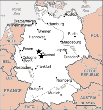
Fig. 1: Map of Germany with indications of investigation areas.
Map: courtesy of The World Factbook.
These examinations give information about the building materials and allow conclusions about the extraction sites and the routes of transport. Furthermore, it is possible to ascertain not only the properties of the building materials, but also those of the extraction sites. Some of the results will be shown and placed in the context of the whole group. (2)
The Hessian and Westphalian tombs are located in the area of the Funnel Beaker Culture and the Wartberg Culture (Schrickel 1966; Günther 1997; Raetzel-Fabian 2000). They were built between 3400 and 3000 calBC and used until 2800, sometimes 2700 calBC. About 50 gallery graves and related forms in Hesse, Westphalia and neighbouring areas are known today. The tombs are deepened into the ground and were covered with a barrow. They are 10 to 35 m long and 2 to 3 m wide. The chamber can be reached through a porthole. The building material is, in the majority of the cases, composed of rectangular slabs of limestone or sandstone. Basaltic stones, erratic blocks, and tertiary quartzite are also used. The tombs can be divided into two main types (Günther 1987, 92).
The so-called type “Züschen” is characterised by an access on the smaller, axial side and an antechamber or vestibule. The so-called type “Rimbeck” has an access more or less in the middle of the longer, lateral side like a Funnel Beaker passage grave.
2. Hesse: “Lohne-Engelshecke I” or Züschen I, Schwalm-Eder Kreis
The famous grave of Züschen I (Boehlau/Gilsa 1898; Kappel 1989) is situated near Kassel, in the Westhessian Lowland, near a little river, which joins further on the river Eder (Fig. 2). The Westhessian Lowland is characterised by Triassic surfaces which are disturbed by ridges of basalt. These now wood covered hilltops are a prominent feature of the landscape. In Neolithic times, they were populated by the people of the later Wartberg culture (Schwellnus 1979; Raetzel-Fabian 2000).
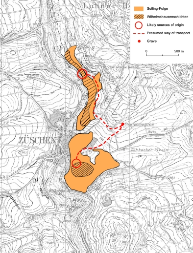
Fig. 2: Map of the Züschen tomb and surroundings with geological
information and presumed routes of transport. Topography:
© German Federal Office for Cartography and Geodesy 2004.
The Züschen grave, which is eponymous for the type as stated above, is 20 m long and has a width of about 3.5 m. Its antechamber measures 2.5 m; the chamber is 16.5 m long. 25 stone slabs are preserved, and were geologically observed and analysed. The consistence of the slabs shows that they are from the so-called Middle Triassic or “Mittlerer Buntsandstein”. On a closer view the stones belong within this formation to the “Wilhelmshausen-Schichten” of the so-called “Solling-Folge”. The stones have a yellowish to brownish-grey colour; the texture is coarse and sandy.
In proximity to the grave six outcrops of the “Wilhelmshausen-Schichten” are visible. Due to their closer vicinity to the tomb and the special properties of the beds, which match the thickness of the stones used, two areas seem most likely the places of the Neolithic exploitation. They are situated north and south of the tomb near the scarps of the little river. For retracing the distance and the course of the route of transport, it is assumed that the way with the least difference in altitude was chosen, even when it was longer than the direct route (Günther 1987, 83-84; Günther 1997, 180). From the area north to the tomb the route of transport from outcrop to grave measures ca.1300 m. The southern route is with just 1000 m shorter, but the northern route is not as steep as this one and as the easier way of access was therefore more likely used (Fig. 2).
2.1. Properties of building materials and extraction sites
The “Wilhelmshausen-Schichten” are exceptional good for winning slab-like building materials. The beds are naturally separated through horizontal and vertical fractures in varied thicknesses. Because of their sandy texture, they could be rather easily extracted from the beds with the use of simple tools as wooden wedges and chisels. The fractures predetermined the form of the slabs. For Neolithic times it can be safely assumed an extraction of the uppermost beds from the surface. These bear deep marks and cracks from weathering through the times, helpful for winning slabs (Fig. 4).
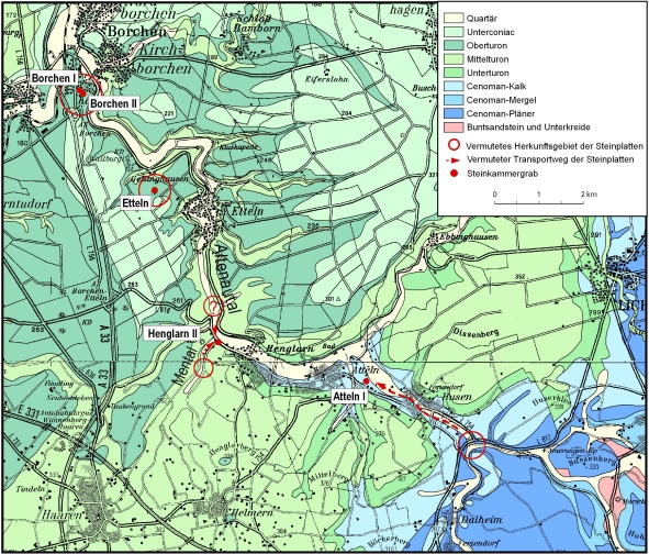
Fig. 3: Map of the valley of the Altenau with geological information and presumed routes of transports.
Geology: Vervielfältigt mit Genehmigung des Geologischen Dienstes NRW - Landesbetrieb -
vom 24.10.2006; Geologische Karte von Nordrhein-Westfalen 1: 100 000, mit Erl. - Hrsg.
Geol.-L.-Amt Nordrh.-Westf.; Krefeld. Blatt C 4318 Paderborn, 2. Aufl. (1985), Bearb.
DAHM, H.-D. et al. Topography: © German Federal Office for Cartography and Geodesy 2004.
In Züschen the majority of the slabs have the same thickness (about 0.5 m), so one can assume that they were extracted from the same bed of sandstone. Two differing slabs with a thickness of approximately 0.2 m and 0.8 m are assumed to come from other beds. The softness of the stones allows an easy processing of the surface. Therefore it was not too difficult to drill the porthole of 50 cm diameter, probably with a stone tool, into it, and to engrave the slabs with symbols. (3)
3. Westphalia: the Altenau valley, Kreis Paderborn
The graves here to be discussed are located in the valley of the river Altenau, close to the city of Paderborn, in North Rhine-Westphalia (Fig. 3). The valley of the Altenau belongs to the Paderbornian plateau, which consists of stones from the Upper Cretaceous and is characterised by dry plateaus, deep incised arroyos and karst springs. There are seven megalithic tombs known today in the valley of Altenau. Five of these sites allowed geological examinations and are described as follows.
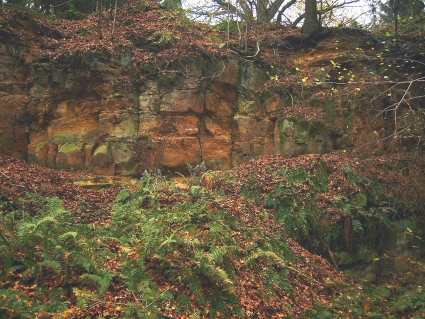
Fig. 4: Outcrop of the Wilhelmshausen-Schichten south of the Züschen
tomb. Courtesy of Dr. J. Farrenschon.
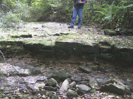
Fig. 5: Riverbed of the river Men; a possible extraction site.
Foto: K. Schierhold.
3.1. Atteln I
The only reconstructed tomb is Atteln I, the southernmost tomb in the valley (Günther 1979). It is situated at the valley’s floor (Fig. 3). The tomb is 21 m long and has a width of 2.5-3 m. The inner width measures 2 m, the inner length 19.5 m. It belongs to the Züschen type with axial access, although there is no antechamber. 16 of the 17 original stones have been surveyed. One of the original stones could not be analysed due to its firm installation at the west side of the reconstruction. Through enclosed fossils the stones can be placed into the Cenomanian, this is the first stage of the Upper Cretaceous. More precisely the beds belonged to the so-called “Pläner” limestone and the so-called “Flaserkalkstein-Folge”. Their colour is grey, but many stones show a yellow to brown coloured surface from weathering. The texture is slightly corrugated and smooth, but at the fissures is crumbly and irregular.
Looking for the outcrops, the beds from the “Pläner” and “Flaserkalkstein-Folge” of the Cenomanian are visible at the confluence of the rivers Altenau and Piepenbach, just southeast of the grave. The best accessible way with the least difference in altitude is along the riverbed of the Altenau. The distance between outcrop and grave measures 2700 to 2800 m. Today, the flood control detention basin is built at the confluence of the rivers Altenau and Piepenbach, but a few areas of the former landscape are visible and reachable. On the scarp adequate slabs can be found, just as the ones used for building the tomb.
3.2. Henglarn II
This grave lies at the border of the flood plain, where the arroyo of the river Men meets the valley of the Altenau (Günther 1980) (Fig. 3). Just one long side survived, the other half was cut down and destroyed during road construction in the 19th century. An erratic block lies nearby and may have been part of the grave structure. The grave belongs maybe to the Rimbeck type, but is due to its destruction difficult to place. The tomb is 18.5 m long and, taking the only preserved stone on the eastern axial side as measure point, about 2.5 m wide. The 14 examined stones consist of limestone of the Middle Turonian, from the so-called “Lamarcki- Schichten”. The Turonian forms the second stage of the Upper Cretaceous. These stones have extremely smooth surfaces especially along the fissures.
Very close to the grave limestone of the Middle Turonian is available. They were probably won from the valleys of the rivers Altenau or Men. The routes of transport along the base of the valley or the riverbeds would have been really short then, only 50 m, or a maximum of 600 m. The limestone of the riverbed of the Altenau is overlaid with medieval alluvial deposits; therefore an extraction site of Neolithic times cannot be stated safely. But in the valley of the river Men these sites are still accessible. Slabs of limestone, same size as used in the tomb, can be found at the embankment as the riverbed itself (Fig. 5).
3.3. Kirchborchen I and II
The graves of and Kirchborchen I and II (Günther 1976; 1978) are presented here together, because they are made of the same building material, and they lay just 120 m apart (Fig. 3). They are situated not in the flood plain, like the tombs of Atteln I and Henglarn II, but on the northern slope of the Limberg, a hill on the western
border of the valley of the river Altenau. Kirchborchen I belongs to the Rimbeck type with the access on the lateral side. It is about 23 m long and 3.5 m wide. The chamber itself measures about 22 m and 2.5 m. 21 stone slabs were geologically examined. The tomb Kirchborchen II belongs to the Züschen type with axial access and antechamber. It is 13.5 m long and 3.8 m wide; the inner measurements are about 11.5 m and 2.8 m for the antechamber. In this case, 22 slabs were analysed. Notable are some surviving capstones at both tombs. All used stones are made of limestone slabs from the Upper Turonian, in particular from the so called “Striatoconcentricus-Schichten”. A characteristic of these slabs are chert enclosures, which are seldom found in the Upper Turonian, and not yet closer localised in the area of Kirchborchen. The two thin porthole-slabs of Kirchborchen II come from a particular bed in the Upper Turonian, the so called Soester Grünsand, which contains a lot of glauconit, a green mineral.
The beds of the Upper Turonian are in immediate vicinity of the graves and very close to the surface. The material for the thin slabs of the Soester Grünsand was located about 250 m away at a construction site. Hence it seems very likely that the most stones were cut out directly at the site of the graves.
3.4. Etteln
The Etteln tomb (Günther 1978) is located in a similar area like the Kirchborchen ones: it lies on the Lechtenberg on the western border of the valley of the river Altenau (Fig. 3). It is 22 m long and 2 to 2.5 m wide; the inner measurements are 21.5 x 2.3-2.8 m. It belongs to the Züschen type, but there is no antechamber on the axial side. 45 slabs, among them several capstones, were looked at closely. Like in Kirchborchen, the consistence of the stones shows that they are from the “Striatoconcentricus-Schichten” of the Upper Turonian. Some of them have the same chert enclosures. The Upper Turonian beds also occur in immediate proximity to the tomb and very close to the surface. Therefore it seems very likely that the slabs where extracted close to the building site.
3.5. Properties of building materials and extraction sites
The used building material for all tombs in the valley of the Altenau is limestone. It comes from two different stages of the Upper Cretaceous, but with similar properties. The bed surfaces and systems of fractures divide these in square and trapezoid slabs and blocks. They could easily be separated by wooden wedges and chisels. Like in Züschen, it is quite certain that only the uppermost beds were exploited. All of the examined stones show natural and unworked surfaces with the fissures as natural borders. Only the porthole-slabs are processed: in the case of Kirchborchen I and II and Etteln, the lower corners of the door-slabs are cut away, so the porthole looks roughly like an arch.
The used stones give more hints of the properties of the special extraction sites. Slabs of varied thickness were utilised in Atteln I and Kirchborchen I and II. This indicates that the mining took place in more than one bed of limestone and in different areas. Although, it can be possible that various thick beds lay upon each other. On the other hand the chert enclosures and the almost same thickness of several slabs used in both tombs, Kirchborchen I and II, refer to an identical bed of limestone. The limestone of the Upper Turonian is in immediate vicinity to the tombs and can be found close beneath the surface. Hence it seems very likely that these slabs were cut out directly at the site of the graves from the upper bed.
The surfaces of some stones from Atteln show traces from being in the water. They are very smooth, and one stone has a karst groove (Fig. 6). This shows a provenance from a riverbed. Other traces of lime solution, with little drop-like forms, can be seen on some slabs in Etteln (Fig. 7). This form of solution indicates a provenance not from a riverbed with running water, but from an uncovered surface, weathered through the times.
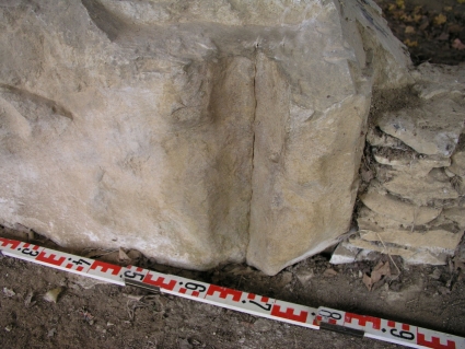
Fig. 6: Karst groove on a slab from Atteln I. Courtesy of Dr. M. Hiß.
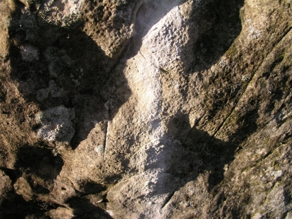
Fig. 7: Traces of lime solution on a slab from Etteln. Courtesy of
Dr. M. Hiß.
4. Comparison and conclusions
The geological examinations enlightened a lot of details concerning the character and properties of the extraction sites. For the extraction sites of other gallery graves in Hesse and Westphalia, similar conditions can be assumed, but are not yet studied in detail. A comparison between the graves of Züschen, the Altenau valley and the other tombs can be drawn concerning the building materials and the presumed distances of transport (Fig. 8). It is very likely that the tombs of Kirchborchen and
Etteln were built in immediate vicinity to the extraction site. Henglarn II shows a distance of less than 1 km, for Atteln I and Züschen I the distance is farther. Limestone and sandstone are the used materials.
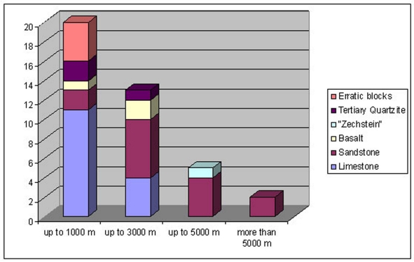
Fig. 8: Table of building materials and presumed distances of transport of 40 gallery graves
and related forms in Hesse, Westphalia and neighbouring areas.
Other gallery graves and related forms in Hesse, Westphalia and neighbouring areas are built from materials like erratic blocks, basaltic stones, tertiary quartzite and „Zechstein“, geologically a part of the Perm. 50% of the tombs are built in close vicinity to the extraction sites. In this case close means a distance up to 1 km. A third of the graves received the stones from a range up to 3 km. Only seven tombs have a presumed route of transport with farther distances; the two farthest of them are 11 and 16 km away. It is geologically acknowledged and must be kept in mind, that for all these tombs no other megalithic building materials were available in closer vicinity.
The surfaces of the stones here examined in detail show us that they come from riverbeds or close beneath the surface. These limestone and sandstone beds with their natural properties of square and trapezoid slabs are perfect for building, and this must have been evident to the master builders of late Neolithic times.
Through the comparison of the provenance of the stones from other gallery graves, it is possible to see two distinctions for the building of the tombs. It becomes obvious that the location of some graves was very probably chosen because of the close vicinity to the extraction sites. But there are several graves with quite a distance to the extraction site. Here it seems that the location was chosen before or for a different reason than the resources (closeness to settlement, holy place, the „need“ to have a megalithic tomb etc.).
Notes:
(1) My special thanks to Marion Uckelmann M.A. for
brushing up my English.
(2) The geological examinations are part of a doctoral
thesis concerning the gallery graves in Hesse and
Westphalia. The full results will be presented there.
(3) See the contribution of A. Jockenhövel/ D. Dirksen/ L. Loerper.
Bibliography:
BOEHLAU, J.; GILSA, F. VON GILSA ZU (1898) – Neolithische Denkmäler aus Hessen. Kassel: Döll. 21 p.
GÜNTHER, K. (1976) – Zu denneolithischen Steinkistengräbern von Kirchborchen, Gem. Borchen, Kr. Paderborn. Germania. Mainz. 54, p. 184-191.
GÜNTHER, K. (1978) – Zu den neolithischen Steinkistengräbern Kirchborchen I und Etteln, Kr. Paderborn. Germania. Mainz. 56, p. 230-233.
GÜNTHER, K. (1979) – Die neolithischen Steinkammergräber von Atteln, Kr. Paderborn (Westfalen). Germania. Mainz. 57, p. 153-161.
GÜNTHER, K. (1980) – Die neolithischen Steinkammergräber von Henglarn, Kr. Paderborn (Westfalen). Germania. Mainz. 58, p. 147-152.
GÜNTHER, K. (1987) – Ein Großsteingrab in der Warburger Börde bei Hohenwepel, Stadt Warburg, Kreis Höxter. Ausgrabungen und Funde in Westfalen-Lippe. Mainz. 4, p. 65-104.
GÜNTHER, K. (1997a) – Die Kollektivgräber-Nekropole Warburg I-V. Mainz: Zabern. 231 p.
GÜNTHER, K. (1997b) – Das Megalithgrab Atteln I. Ein Grabmal jungsteinzeitlicher Bauern und Viehzüchter im Paderborner Land. Archäologie in Ostwestfalen. Bielefeld. 1, p. 14-15.
KAPPEL, I. (1989) – Das Grab von Züschen. In Steinkammergräber und Menhire in Nordhessen. Kassel: Staatliche Kunstsammlungen Kassel. p. 17-23. (Führer zur nordhessischen Ur- und Frühgeschichte 5).
RAETZEL-FABIAN, D. (2000) – Calden. Erdwerk und Bestattungsplätze des Jungneolithikums. Architektur, Ritual, Chronologie. Bonn: Habelt. 370 p.
SCHRICKEL, W. (1966) – Westeuropäische Elemente im neolithischen Grabbau Mitteldeutschlands und die Galeriegräber Westdeutschlands und ihre Inventare. Bonn: Habelt. 499 p.
SCHWELLNUS, W. (1979) – Wartberggruppe und hessische Megalithik. Ein Beitrag zum späten Neolithikum des Hessischen Berglandes. Wiesbaden: Landesamt für Denkmalpflege Hessen. 94 p.