
News
March 2019: New URL for GEO1copter !!
(https://copter.ifgi.de/ )
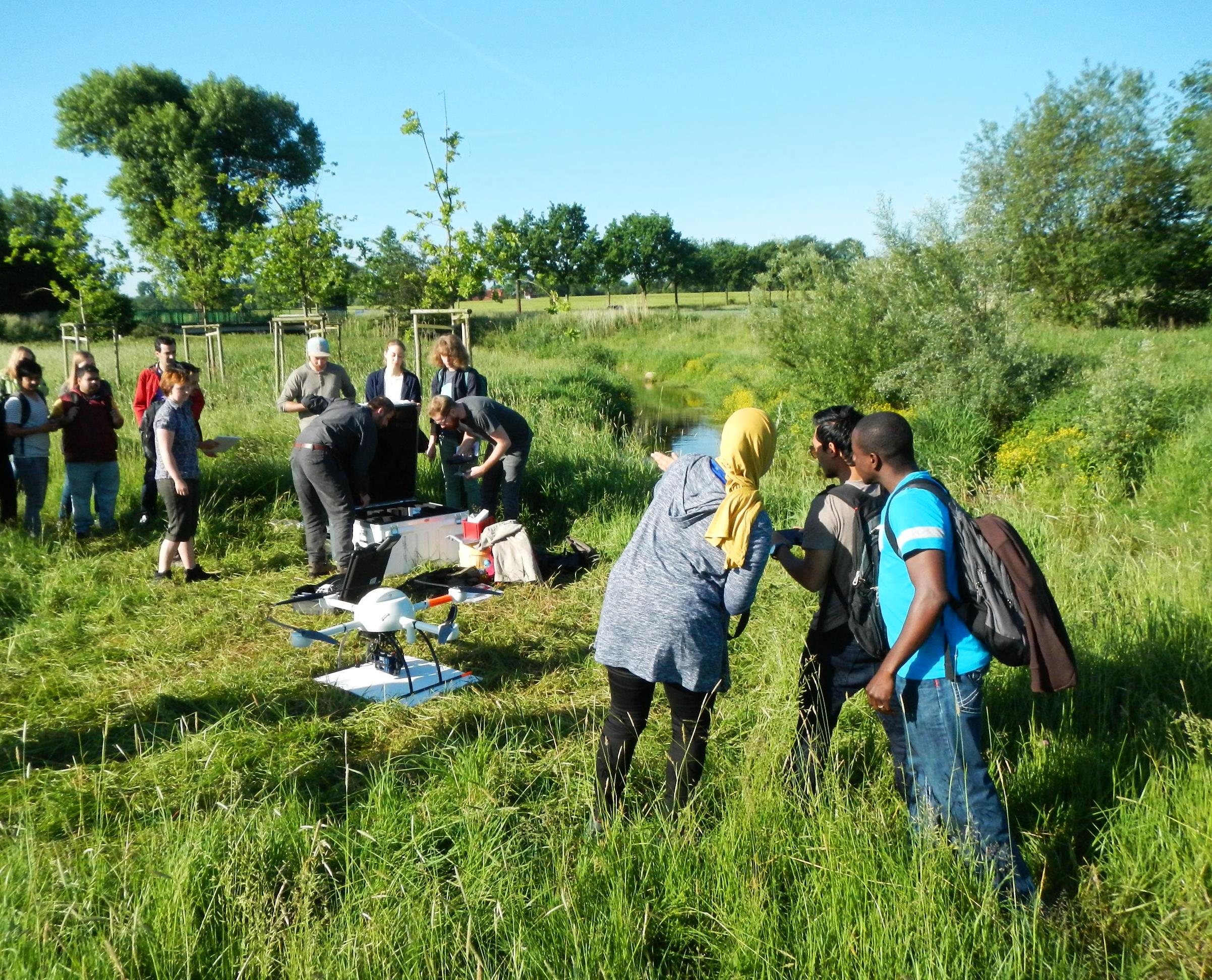
April 2018 - UAV-Workshop 'Geospatial Technologies' with international student participants
During the summersemester 2018 the second international UAV-Workshop 'Geopspatial Technologies' takes place, gathering more then 25 students out of 12 countries at IFGI. Focus is set on geodata acquisition by UAV, renaturation and monitoring issues, UAV image- and video-analysis and web-based geodataportals. The IFGIcopter-groupe is in charge of administration.
November 2016 - IFGIcopter 3.0 - new interdisciplinäry framework of the IFGIcopter group!
From the 18. of November the IFGIcopter group will be lead by a new interdisciplinary GEO-crew: Dr. Florian Hillen (IFGI), Dr. David Ott and MSc Jan Lehmann (both ILÖK) togehter with Dr. Torsten Prinz and Dipl. Geogr. Christian Knoth (both IFGI) will co-ordinate the future scientific activities and projects as a direct consequence of the increasing interdisciplinary focus of UAV/UAS applycations in the field of Geoinformatic and Environmental sciences.
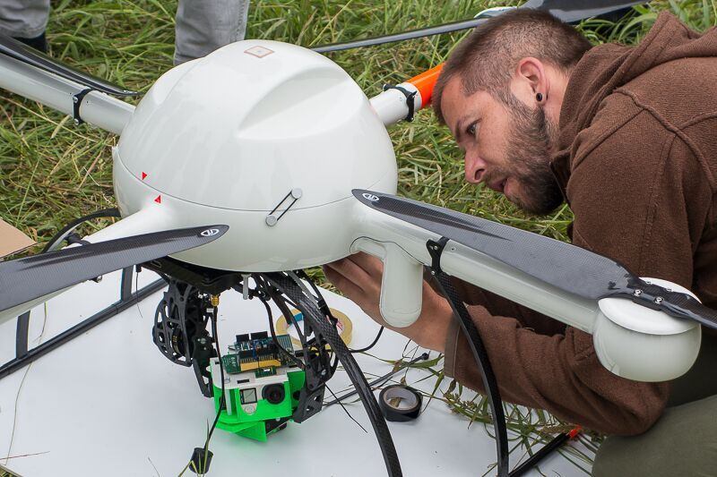
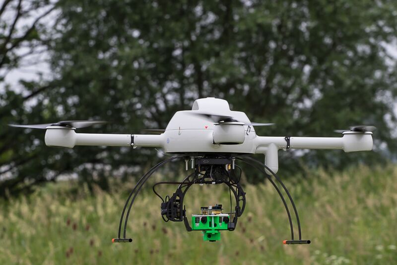
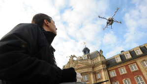
First MD4-1000 (Microdrones) flight with 360° GoPro imaging system by IFGIcopter!
End of June 2016 a first test flight of our new MD4-1000, fitted with a 360° GoPro-Gimbel (consisting out of 5 GoProm Cams) along the upper river Aa was successfully carried out during this semesters Geospatial Sciences Workshop. The archieved 360° Video data will be part of a scientific visualisation project at the IFGI. The Quadrocopter type MD4-1000 by the german manufacturer Microdrones belongs to the fleet of the IFGIcopter-Team since october 2015. Its typical field of usage is geoscientific multispectral imaging, carrying sensors like Tetracam or others.
Description
 Unmanned Aerial Vehicles/Systems (UAV/UAS) as highly flexible and low-cost sensor platform provide new opportunities of data acquisition for various environmental- and geoscientific purposes (e.g. environmental monitoring, forestry, geobase data etc.). Its spatial and temporal versatility due to small size, low weight and little operating costs also makes these UAVS an attractive tool for monitoring and observation purposes in precision agriculture. From 2009 on the ifgicopter group of the Institute for Geoinformatics is working on applications of UAV/S in the various fields of geoinformation science. In particular, three different UAV/S systems (microdrones and mikrokopter, fixed wing systems) form the starting point of the ongoing research. The current areas of work and research topics of the ifgicopter group cover real-time data processing, related geoservices, near-infrared aerial photography and high-precision positioning.
In March 2015 the relaunch of the group as IfgiCopter 2.0 took place with a stronger focus on applied ecological projects in terms of geodata sampling and analysis (e.g. in collaboration with the Institute of Landscape Ecology).
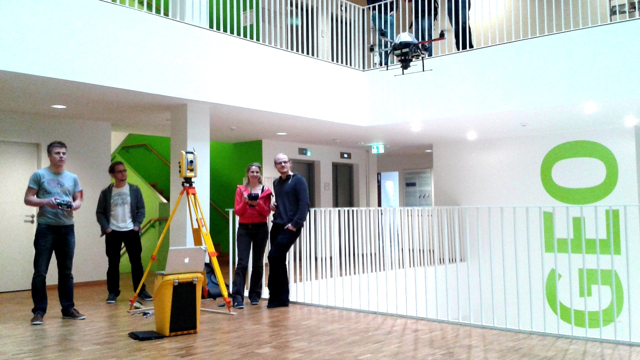 Our UAS fleet comprises different types of drones, like
- AR Drones
- Mikrocopters
- Microdrones
- Skywalker (fixed wing UAS)
| Period | since 2010 |
|---|---|
| Status | In Progress |
Events
Events
n.V. Flugschule - UAV Gruppe ILÖK/IFGI (intern)
04.09.-07.08.2017 - UAV-g Conference (Bonn)
27.05.2017 - UAV und Landwirtschaft - CBA Potsdam
21.04.-13.07.2017 - UAV Applications in Geosciences (international Mundus Master) Workshop (IFGI)
26.10.-11.01.2017 - UAV Seminar IFGI (intern)
21.05.-13.07.2016 - UAV Geospatial Science Seminar (IFGI)
21.05.2016 - UAV und Landwirtschaft - CBA Wernigerode
Persons
Current Members
Dr. Torsten Prinz (Projectleader, IFGI)
Dr. Florian Hillen (Projectleader, IFGI)
Dr. David Ott (Projectleader, ILÖK)
Christian Knoth (Projectleader, Phd-Cand. IFGI)
Jan Lehmann (Projectleader, Phd-Cand. ILÖK)
Felix Nieberding (Masterstudent, ILÖK)
Peter Sulmann (Electronic-Lab)
Simon Schulte (Masterstudent, IFGI), IFGI)
Maximilian Twelsiek (Bachelorstudent, IFGI)
Marlena Götza (Masterstudent, IFGI)
Stefanie Kölker (Masterstudent, IFGI)
Niklas Trzaska (Masterstudent, IFGI)
Former Staff
Prof. Dr. Edzer Peebesma (Projectleader, IFGI)
Kristina Knoppe (Master, Geoinformatics)
Dustin Demuth (Master Geoinformatics)
Katharina Haubeck (Diploma, Geography)
Jakob Geipiel (Master, Geoinformatics)
Malte Hübner (Diploma, Geography)
Juliane Brink (PHd)
Stephanie Walter (Master, Geoinformatics)
Matthes Rieke (Master, Geoinformatics)
Sarah Mers (BSc, Geoinformatics)
Heinrich Löwen (BSc, Geoinformatics)
Mario Gerdes (BSc, Geoinformatics)
Tobias Brüggentisch (BSc, Geoinformatics)
Fabian Röhr (Masterstudent, IFGI)
Research Topics
Real-Time Data Processing
The used UAV/S platform is enhanced with a standalone computing board managing the interaction with the actual sensors (a Sensirion SHT75 temperature/humidity sensor). Based on this approach we are able to easily integrate new sensors to the multi-sensor platform as it is completely independent of the UAV/S-specific electronics. Hence the developed computing board can be deployed on both UAV/S systems.
Using an independent sensor board with a separated wireless downlink lead to problems while processing the data. Different phenomena (e.g. GPS position, temperature) arrive at different timestamps at the groundstation. To overcome this issue we developed a software framework capable of synchronizing multiple data streams and subsequently transform the raw data into higher level protocols like Observation & Measurements. Thus we are able to integrate the gathered data into several services of the Sensor Web. For a description of the framework see SensorPlatformFramework.
Near-Infrared Aerial Imagery and Oblique Photography
In order to establish a sensor setup for aerial photography in the visible (VIS) and near infrared (NIR) spectrum, the UAV/S platform is equipped with a compact digital camera which has been modified by removing the internal infrared-cut-filter (hot mirror) and is now capable of capturing radiation from about 330nm to 1100nm. The effectively captured spectra can be restricted by applying several optical filters absorbing specific ranges of the incoming radiation (e.g. VIS-only, NIR-only). As a further option the camera can be equipped with a self-built color filter which absorbs only the visible red radiation to enable photography of color infrared (CIR) images containing the information of the blue, green and NIR light.
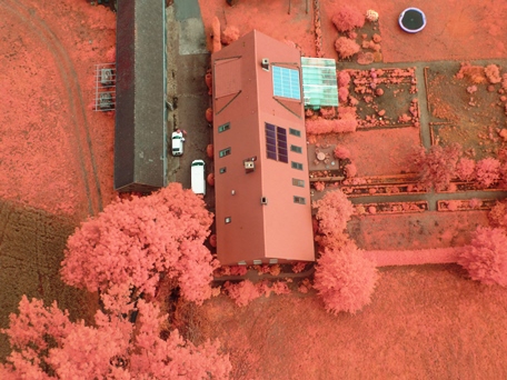
UAV Colour Infrared Image (CIR) of a farm site near Münster
The enhanced spectrum of the camera qualifies it for several monitoring and observation tasks, particularly concerning ecological vegetation analysis. Therefore the images obtained from aerial surveys are being rectified using ground control points measured a priori. Because of the high spatial resolution much information can be extracted not only from the spectral but also other (e.g. shape, texture) characteristics.
Another scientific aspect is the possible geoinformatic explotation and support of building damage classifications, environmental framesets or achaelogical surveys by use of UAS Oblique/3D Aerial Imagery.
Detection, monitoring and analysis of dynamic patterns in environmental phenomena
An important task considering future work is to establish an analytic workflow for the integration of gathered UAV data for issues of dynamic pattern recognition in environmental phenomena like biodiversity, pest, vegetation structures or even routing in dense human crowds by optical or thermal aerial imaging and video data. Therefore UAV- sensors like very high resolution cameras or thermal scanners are beeing tested and used for geoinformatic and environmental scientific purposes.

Image: Hillen, F., Höfle, B., Ehlers, M. & Reinartz, P. (2013): The Potential of Agent-Based Modelling for Verification of People Trajectories Based on Smartphone Sensor Data. In: Proceedings of 8th International Symposium on Digital Earth 2013. Sarawak, Malaysia, pp. 1-6.
Schulte, S., Hillen, F., & Prinz.T. (2017): Analysis of combined UAV-based RGB and thermal remote sensing data: A new approach to crowd monitoring. - in: ISPRS Archives of the Photogrammetry, Remote Sensing and Saptial Information Sciences. , XLII-2/W6, p. 347-354, https://doi.org/10.5194/isprs-archives-XLII-2-W6-34 (Bonn).
Lehmann, J., Münchberger, W., Knoth, C., Blodau, C., Nieberding, F., Prinz, T., Pancotto, V. and Kleinebecker, T. (2016): High-Resolution Classification of South Patagonian Peat Bog Microforms Reveals Potential Gaps in Up-Scaled CH4 Fluxes by use of Unmanned Aerial System (UAS) and CIR Imagery. - In: Remote Sensing of Biogeochemical Cycles (eds. Miller,L. & Cien, C.C.), Remote Sensing 8 (3), 173; doi:10.3390/rs8030173 (MDPI, Basel).
Stüwe, P., Prinz, T. & Satjos, I. (2016): UAS gestützte Bilanzierung von Torfabbauflächen - Ein prototypischer Ansatz zur Integration von 3DPunktwolken zur halbautomatisierten Klassifikation von Torfmieten in ArcGIS. Abstract (Computer- Bildanalyse in der Landwirtschaft/CBA 2016), Tagungsband, (Podsdam/Wernigerode
Lehmann, J.R.K.; Nieberding, F.; Prinz, T.; Knoth, C. (2015): Analysis of Unmanned Aerial System-Based CIR Images in Forestry—A New Perspective to Monitor Pest Infestation Levels. Forests, 6, 594-612 doi. 10.3390/f6030594.
Lehmann, J. R. K.; Smithson, K. Z.; Prinz, T. (2015): Making the invisible visible: using UAS-based high-resolution color-infrared imagery to identify buried medieval monastery walls. J. Unmanned Veh. Sys., 3, 58–67. doi. 10.1139/juvs-2014-0017.
Knoth, C., Prinz, T. & Loef, P. (2010): Mircocopter-Based Color Infrared (CIR) Close Range Remote Sensing as a Subsidiary Tool for Precicision Farming. - ISPRS Workshop on Methods for Change Detection and Process Modelling, 7 p., Univ. Press Cologne (Cologne).
Geipel, J., Knoth, C., Elsässer, O. & Prinz, T. (in press 2011): DGPS- and INS-Based Orthophotogrammetry on Micro UAV Platforms for Precision Farming Services. - Short Paper in: UAV Workshop at GEOINFORMATIK 2011; 6 p., (Münster).
Rieke, M., T. Foerster, J. Geipel & T. Prinz (2011): High-precision Positioning and Real-time Data Processing of UAV-Systems. Extended Abstract in UAV-g 2011: Unmanned Aerial Vehicle in Geomatics. September 14-16, 2011; 12p., (Zuerich).
Kleinebecker, T., Knoth, C., Klein, B. & Prinz,T. (2012): Can unmanned aerial vehicles as innovative remote sensing platforms support restoration monitoring in cut-over bogs? - Working Group Ecosystem Research Meeting 2012, Abstract/Poster, Workshop Budweis (CZ).
Knoppe, K. & Prinz, T. (2013): 3D Information from an UAV-based close-range Stereoscopic System for Web Mapping Services (WMS). Abstract forthcoming extendet paper in: UAV-g 2013 (Rostock).
Fritze, H., Walter, S. & Prinz, T. (2013): Facilitating UAS-based oblique imagery to support Urban Search and Rescue Operations. Abstract forthcoming extendet paper in: UAV-g 2013 (Rostock).
Knoth, C., Klein, B., Prinz,T. & Kleinebecker, T. (2013): Unmanned aerial vehicles as innovative remote sensing platforms for high-resolution infrared imagery to support restoration monitoring in cut-over bogs. 9p., Applied Vegetation Science, Vol. 3 (Wiley Press, Oxford, Tornto, New York).
Haubeck, K. & Prinz, T. (2013): A UAV-based low-cost stereo camera system for archaeological surveys - experiences from Doliche (Turkey). International Archives of the Photogrammetry, Remote Sensing and Spatial Information Sciences, Volume XL-1/W2, 2013 UAV-g2013, 4 – 6 September 2013 (Rostock).
Lehmann, J. , Hejkal, J. & Prinz, T. (2013): UAV-based monitoring of invasive HERACLEUM MANTEGAZZIANUM (giant hogweed) and FALLOPIA JAPONICA (japanese knotweed) in riperian habitats. International Archives of the Photogrammetry, Remote Sensing and Spatial Information Sciences, Volume XL-1/W2, 2013 UAV-g2013, 4 – 6 September 2013 (Rostock).
Haubeck, K. & Prinz, T. (2014): 3D- Oberflächenerfassung und Orthophotogenerierung mittels eines UAS-basierten Stereokamerasystems am Beispiel der archäologischen Grabungsstätte Doliche (Türkei). gisScience 1/14, Wichmann Verlag (Germany).
Prinz, T., Walter, S., Wieghardt, A., Karberg, T. & Schreiber, T. (2014): GeoArchaeology Web 2.0: Geospatial Information Services Facilitate New Concepts of Web-Based Data Visualization Strategies in Archaeology—Two Case Studies from Surveys in Sudan (Wadi) and Turkey (Doliche). In: Archaeological Discovery (Vol.2, No.4), Article 16p., Scientific Research Publishing (Delaware).
Thesis
Open BSc- and MSc-Thesis topics:
- Analyse photogrammetrisch erzeugter, UAV-basierter 3D-Punktwolken zur Dokumentation kulturistorisch bedeutsamer Viadukte im 3D-Druck - die Berkelbrücke bei Vreden.
Own smart research topics are also welcome!
Laufende Arbeiten
2016
- M. Twelsiek: Klassifikation von Rauigkeitswerten von Waldoberflächen für die Eddy-Kovarianz Abschätzung mittels UAV Punktwolken. BSc-Thesis (IFGI); Examiner: Dr. T. Prinz & Jan Lehmann.
- B. Klein: Drohnengestütze Fernerkundung zur Ermittlung der Vitalität von Feuchtwäldern. MSc-Thesis (External GI); Examiner: Jan Lehmann & NN.
- P. Stüwe: Bilanzierung von Torfabbauflächen anhand hochauflösender UAS-Daten unter Nutzung des ArcGIS ModelBuilders. BSc-Thesis (IFGI); Examiner: Dr. T. Prinz & Sven Hapering (ESRI).
- B. Junge: Analysemöglichkeiten UAV-gestützter, hochauflösender ixu 1000 Kameradaten mithilfe ArcGIS 10.4 Ein Beispiel aus dem Rapsanbau. BSc-Thesis (IFGI); Examiner: Dr. T. Prinz & J. Lehmann.
- M. Rieping: Möglichkeiten und Potentiale der neuen ESRI-Software Drone2Map im Hinblick auf die Analyse und Einbindung von UAV-basierten Fernerkundungsdaten in Geoinformationssystemen. BSc-Thesis (IFGI); Examiner: Dr. T. Prinz & C. Knoth.
- J.M. Caldieron: Understanding the past, present and future conditions of selected informal settlements in Mongolia by use of GIS and Remote Sensing Techniques. PHd-Thesis (IFGI/Geopsatial Sciences); Examiner : Dr. Torsten Prinz & NN.et al.
- M. Köster: Visuelle Darstellung vertikaler CIR-Videostreams von ökologisch relevanten vertikalen Strukturen mittels einer AR-Drone in einem Web-Portal. BSc-Thesis (IFGI); Examiner: Dr. T. Prinz & Sven Hapering (ESRI). BSc-Thesis (IFGI); Examiner: Dr. T. Prinz & T. Bartoschek.
- J. Lehmann: Unmanned Aerial Systems (UAS) in Landscape Ecology: Applications and Perspectives for Scaleable Multispectral Remote Sensing and Image Analysis Strategies. PHd-Thesis; Examiner: Prof. Dr. T. Buttschardt et NN.
2015
- J. Lehmann: Exploring the Mussununga Ecosystem (Brazil) by use of UAS CIR-Photography and Field Data. Working Group Topic. Prof. Dr. T. Buttschardt et Dr. Torsten Prinz.
- M. Köster: AR-Drone CIR Video mapping for Ecological purposes. BSc-Thesis; Examiner: Dr. Torsten Prinz et NN.
- D. Ummelmann: LiDAR-Lite: Mögliche Potentiale eines Crowd-Sourced Low-Cost LiDAR-Systems für geoinformatische Applikationen. BSc-Thesis; Examiner: Dr. T. Prinz et NN.
- E. Troncho Jordan: A Prospective Geoinformatic Approach to Indoor Navigation for Unmanned Air System (UAS) by use of Quick Response (QR) codes. MSc-Thesis; Examiner: Prof. Dr. I. Guerrero, T. Prinz & R. Enriques (Geospatiall Sciences).
Abgeschlossene Arbeiten
2014
- T. Brüggentisch: Erweiterung der RESTful API um die Integration von 3-dimensionalen UAS-Daten sowie deren Visualisierung mithilfe eines WebGIS. BSc-Thesis; Examiner: Dr Jirka & Dr Prinz – Supervisor: Jirka.
- S. Mers: Entwicklung einer GI-Architektur zur Integration tachymetrischer UAS-Höhendaten in ein Sensornetzwerk. BSc-Thesis; Examiner: Rieke & Dr Prinz – Supervisor: Prinz.
- H. Löwen: Title t.b.a. BSc-Thesis; Examiner: Dr Jirka & Dr Prinz – Supervisor: Jirka.
- D. Schumacher: Map-based interactions with mobile video data: Possibilities and potentials in Emergency Management. BSc-Thesis; Examiner: Fritze M.Sc. & Dr Prinz – Supervisor: Fritze.
- F. Nieberding: Klassifikation feuerländischer Moorvegetation mit Hilfe hochauflösender multispektraler Bilddaten. BSc-Thesis; Examiner: PD Dr Kleinebecker & Dr Prinz – Supervisor: Prinz.
- K. Haubeck: Möglichkeiten der 3D-Erfassung historisch-geographisch relevanter Oberflächenformen mittels eines UAV-basierten Stereokamerasystems am Beispiel der archäologischen Grabungsstätte Doliche (Türkei). Diploma-Thesis; Prof. Reuber & Dr. Prinz – Supervisor: Prinz.
- O. Soloviov: Geospatial assessment of pest-induced forest damage through the use of UAV-based NIR imaging and GI-technology. MSc-Thesis; Prof. NN Geospatial Sciences & Dr. Prinz – Supervisor: Prinz.
2013
- S. Walter: Geoinformatic Aspects of Building Damage Classification with Oblique Aerial Images. BSc-Thesis; Examiner: M.Sc. Fritze & Dr. Prinz – Supervisor: Fritze.
- K. Knoppe: A Lightweight Digital Stereoscopic Camera System for Micro-UAV Photogrammetry Applications in Geoinformatics. MSc-Thesis; Prof. Kray & Dr. Prinz – Supervisor: Prinz.
- P. Steffen: Analyse feldspektrometrischer sowie UAV-basierter CIR-Bilddaten zur Detektion anthropogen bedingter Vegetationsanomalien am Beispiel der ehemaligen Klosteranlage Klein Burlo. BSc-Thesis; Examiner: Dr. Kleinebecker & Dr. Prinz – Supervisor: Prinz.
2012
-
K. Drerup: An automatic web-based framework to integrate UAV-based data into precision farming applications. MSc-Thesis; Examiner: Dr. Förster & Dr. Prinz – Supervisor: Förster. - J. Geipel: Improved DGNSS-based Positioning of Micro UAV Platforms for Sensor Web Services. MSc-Thesis; Prof. Pebesma & Dr. Prinz – Supervisor: Prinz.
- S. Ottenhues: Integration von Rasterdaten in ein web-basierte Flugplanungstool für UAV’s. BSc-Thesis; Examiner: Dr. Förster & Dr. Prinz – Supervisor: Prinz.
2011
- E. Beyene Tesfamariam. Distributed Processing Of Large Remote Sensing Images Using MapReduce, Diploma thesis. Examiner: Dr. Foerster – Supervisor: Dr. Foerster & Henneboehl.
- C. Knoth: Prototypische Entwicklung eines UAV-gestützten Fernerkundungssystems zur Generierung hochauflösender Geodaten für den Präzisionspflanzenbau. Diploma-Thesis; Examiner: Prof. Reuber & Dr. Prinz – Supervisor: Prinz.
- O. Elsässer: Rahmenbedingungen einer direkten Orthoreferenzierung digitaler Kleinformat-Luftbilder am Beispiel des UAV Ifgicopter-Projektes. BSc-Thesis; Examiner: Prof. Pebesma & Dr. Prinz – Supervisor: Prinz.
2010
- M. Rieke. Entwicklung eines Frameworks zur Anbindung von Multi-Sensor-Plattformen an das Sensor Web, Diploma thesis. Examiner: Prof. Pebesma & Dr. Prinz – Supervisor: Jirka.
- A. Bruehl. Restful WPS – Geoprozessierung für das Web 2.0, Diploma thesis. Examiner: Dr. Foerster & Dr. Remke – Supervisor: Dr. Foerster & Schaeffer.
- Felix Bache. Development of a Graphical Creator for Sensor Interface Descriptors, Diploma thesis. Examiner: Dr. Remke, Prof. Pebesma – Supervisor: Bröring
- Stefan Below. Concept and Implementation of a Generic Communication Interface for Sensors Based on OGC Standards, Diploma Thesis. Examiner: Dr. Remke, Prof. Pebesma – Supervisor: Bröring
- Thorsten Deelmann. Ad-hoc pay-per-use von standardisierten Geoprozessierungsdiensten in der Cloud, Diploma Thesis. Examiner: Dr. Remke, Dr. Foerster – Supervisor: Schaeffer, Baranski
- Stephan Kuenster, Alexander Strotmann. SOS-X – Konzeption und prototypische
Implementierung eines kaskadierenden Sensor Observation Service, Diploma ThesisExaminer: Dr. Remke, Prof. Pebesma – Supervisor: Stasch - Kristina Knoppe. Bringing a Mobile Water Gage into the Sensor Web Using the Sensor Bus, Bachelor Thesis. Examiner: Dr. Remke, Bröring
- Damian Lasnia. Crowdsourcing Sensor Tasks to a Socio-Geographic Network, Bachelor Thesis. Examiner: Dr. Remke, Prof. Krüger – Supervisor: Bröring
- Carsten Priess. Analysis and Concept of a Bussystem to Integrate Sensors and the Sensor Web, Diploma Thesis. Examiner: Dr. Remke, Prof. Pebesma – Supervisor: Bröring
- Thomas Remmersmann. Visualization of Standardized Sensor Data with an AJAX-based Web Interface, Bachelor Thesis. Examiner: Prof. Bauer, Bröring
- Christian Schmidtchen. Video-based Mobile Water Gage for the Sensor Web, Bachelor Thesis. Examiner: Prof. Pundt, Bröring
- Redweik, R. Providing on-demand GIS functionality in the Cloud, Bachelor Thesis. Examiner: Dr. Remke – Supervisor: Baranski
- Stühle, T. Erweiterung einer Web Processing Service-Schnittstelle um Profile und Taxonomien am Beispiel vermessungstechnischer Berechnungen, Diploma Thesis.
2009
-
Örtel, B. Menschliche Interaktionen in SDI-basierten Geoprocessing-Workflows, Diploma Thesis. Examiner: Prof. Pebesma – Supervisor: Baranski, Schaeffer
- Eike Hinderk Juerrens. SWE-Connection to a GSM-Interface to Establish
Water Availbility Monitoring in Africa, Diploma thesis.
2008
- Thomas Everding. Konzeption und Implementierung eines Prototypen zur Verarbeitung von Sensordatenströmen basierend auf SensorML, Diploma thesis.
2007
- Arne Bröring. Entwicklung eines Frameworks zur Visualisierung standardisierter Geodaten im Rahmen der SWE Initiative, Diploma thesis. Examiner: Prof. Streit, Prof. Krüger – Supervisor: Foerster
- Bastian Schäffer. Integrated Web Geoprocessing Workflow Composition and Deployment, Diploma thesis. Supervisor: Foerster
- Christoph Stasch. SOSmobile – Konzeption und prototypische Entwicklung eines Sensor Observation Service für mobile Sensoren, Diploma thesis. Examiner: Prof. Streit, Prof. Krüger – Supervisor: Walkowski