GrünSchatz - Wild flower mixtures for biogas production
Driven by the global markets, the move away from fossil fuels and the support instruments of agriculture and the Renewable Energy Sources Act (EEG), both new animal fattening facilities and biogas plants have established themselves in the landscape. With them, the area under maize, the number of biogas plants and the installed electrical capacity increased. The changes in the landscape that can already be observed today are so far-reaching that from the point of view of almost all actors (agriculture, nature conservation, tourism, hunting, beekeeping, science, politics, regional development) there is an urgent need for action.
The GrünSchatz project aims to find innovative and exemplary solutions to conflicts that arise from the diverse demands on the landscape.
The project "Pathways to Diversity - Lifelines on Sand" has set itself the goal of preserving and connecting nutrient-poor sandy sites. They are the common characteristic in the Hotspot 22 region of southern Emsland and northern Westphalian Bay. Such sites can often still be found as linear structures along roadsides or sandy banks of still and flowing waters.
Green Border Network - Nature without Borders between North Rhine-Westphalia and the Netherlands
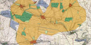
Within the framework of the model project "Green Border Network - Nature without Borders between North Rhine-Westphalia and the Netherlands" (E+E project) of the Federal Agency for Nature Conservation (BfN), in cooperation with the North Rhine-Westphalia branch of the German Nature Conservation Union (NABU, NRW branch), the Working Group on Applied Landscape Ecology and Ecological Planning (AG
Applied Landscape Ecology and Ecological Planning, together with the Working Group on Local, Regional and Land Development/Regional Planning of the Institute of Geography at the University of Münster, participated in the scientific research accompanying the implementation of the project.
The aim of the project was the exemplary realisation of cross-border biotope network projects on the German-Dutch border.
The task of the Applied Landscape Ecology and Ecological Planning Research Group was to evaluate the project measures during the process and to make a final assessment of their ecological functionality.
The results were published in:
Transboundary Biotope Network - Approaches and Challenges for Planning and Nature Conservation Practice.
Nature Conservation and Biodiversity, issue 146.
available here
Effects of historical land-use change on species richness and community composition in fragmented and newly created habitats
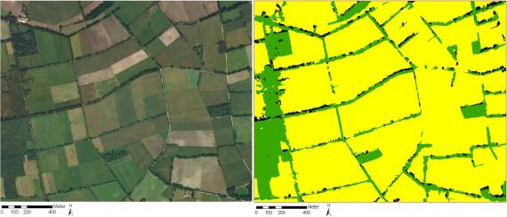
Historical land-use change may have considerable influence on current communities of species. For example, previous land use may have had long-lasting effects on site conditions and “old” species may persist in the community or in the soil seed bank. At landscape scale, land-use change may lead to drastic changes of the area and connectivity of habitats. Strong changes of landscape structure may affect species richness and composition of today’s communities.
In the frame of the DFG priority programme Biodiversity Exploratories, we study effects of historical land use between 1850 and 2010 on current communities of plants and arthropods in grasslands. For this purpose, the historical land use will be reconstructed from digitalised maps (e.g. Prussian “Urmesstischblätter”) in GIS.
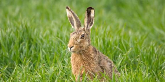
Monitoring project Hegebeauftragter für das Münsterland (Game Management Officer for the Münsterland)
The Landesjagverband (LJV) is the commissioned project sponsor of the Westphalian Cultural Landscape Foundation. In the administrative district of Münster, with the help of an advisor, questions of concrete small game management, support in applying for subsidies and the optimal design and selection of management measures will take place. The main topics are:
Questions on small game management between hunters and potential users of the outdoor area (landowners, hunting ground owners, authorised hunters and farmers).
Mediation of measures and projects concerning species protection in the cultural landscape
To check the project, monitoring will be carried out, which has both an ecological and acceptance-related component.
Get to know and experience Westphalia's natural heritage
Nowadays, everything should be as individual as possible and tailored to the customer's wishes: sandwiches to put on yourself, perfume to create yourself, muesli to mix yourself... And the nature lovers, where are they? Why not put together your own hiking route according to your own interests and needs?
This should be realised in the project "Network FFH identities". With a smartphone app, hiking and cycling enthusiasts in the Coesfeld district can create their own personal route. For this purpose, various thematic areas can be selected, such as oak-hornbeam forests + fire salamanders + sandstone pits, and possible routes are made available on the overview map in the system via the app. On the one hand, the route leads to the various sights and natural monuments (POI "Point of Interests") to be admired. On the other hand, you can use the app to call up pictures, short films or audio files that convey background knowledge - smartphone + nature experience in one, so to speak...
Understanding and valorizing tangible and intangible relations in cultural rural landscapes
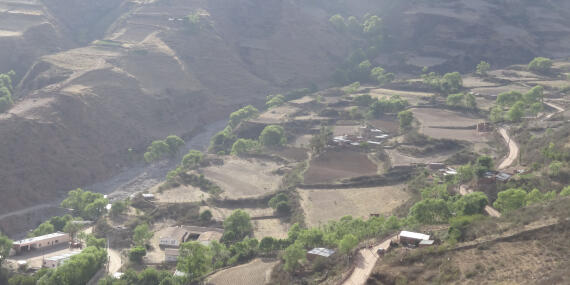
A deeper understanding of the tangible and intangible interactions between societies and the environment is fundamental for transition to sustainable agriculture. Different geographical, social, economic and cultural settings, as well as discursive framings, shape peoples’ relations to land and nature. My doctoral project investigates this diversity of landscape perceptions from discourse studies, combined with the analytic views of 'cultural landscapes' and 'ecosystem services'. The field work applies ethnographic methods in rural communities of the northern Andes of Argentina and the Dolomites in South Tyrol, Italy. The aim is to distinguish different discursive framings of sustainable land use, and various dimensions of well-being in landscape that support agrobiodiversity. In view of an increasing internationalization of society, it is precisely the cultural character of landscapes that makes them an interesting field for intercultural research.
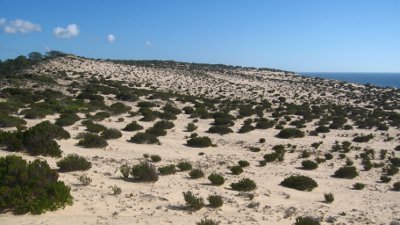
Climate change, soil degradation and the need of alternative energy sources are main challenges at the beginning of the 21st century. Exotic plant species are introduced on purpose for wood production, CO2 sequestration and soil amelioration. Some of these exotics spread out without control and are able to facilitate their invasion into native ecosystems by altering habitat properties. These so-called “invasive ecosystem engineers” can become a threat to biodiversity, ecosystem function and human health. The processes of biological invasions, their impacts on native ecosystems on different temporal and spatial scales, and the invasibility of different ecosystems are still not well understood. The aim of the INvasive SPecies Evaluation, ConTrol & EDucation.NETwork (INSPECTED.NET) is to set up a multi-skilled, international group of experts in biological invasions that will add on to existing programmes like the European-based DAISIE or the global invasive species programme (GISP). As a model, we will examine the invasion by the ecosystem engineer Acacia longifolia applying the latest methods in vegetation ecology including stable isotope analysis and remote sensing.
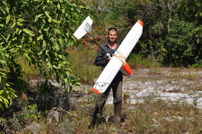
Exotic invasive species represent a major threat to earths biodiversity, since they substantially alter biogeochemical cycles of ecosystems with large impacts on ecosystem functioning. However, to date, explicitly quantifying such impacts remains challenging. One reason is the lack of adequate methodology to capture the spatial dimension of ecosystem changes associated with biological invasion. Conventional ecophysiological approaches are largely restricted to comparing neighbouring plant individuals and tend to neglect the spatial dimension. Landscape ecology, although operating on larger spatial scales, is typically limited to measurements of patterns and processes above the organism level, such as species distribution and propagation speed. The central aim of this project is to link ecophysiology with landscape ecology, thus moving towards an integrated understanding of the spatial aspect of plant invasions, enabling the quantification of exotic species impacts across spatial scales. A highly suitable technology to address this purpose is hyperspectral remote sensing, which allows for quantifying alterations in native species biochemistry on the leaf level using spectral measurements while allowing to scale up to the landscape level using aerial images. Utilizing the case study of the N2-fixing leguminous tree Acacia longifolia, a problematic invader in coastal regions of Portugal and many ecosystems worldwide, we will develop new methodology for quantifying changes in ecosystem functioning after plant invasion from the leaf to the landscape scale.
Permeability and gap crossing: modelling landscape resistances for different functional groups of arthropods and plants
Landscapes can impede dispersal of species to various degrees. Resistances of landscapes also depends on species’ dispersal abilities. We model landscape resistance for different functional groups of species based on circuit theory (Circuitscape).
We use the software Circuitscape for calculations of landscape resistances and assess local resistance values of land-use and land-cover types based on empirical data (e.g. similarity indices of sample plots).