
Ongoing third-party funded projects
DESMEX: Deep Electromagnetic Sounding for Mineral Exploration
DESMEX comprises a series of projects to develop and demonstrate airborne electromagnetic geophysical methods for deep exploration problems. DESMEX is funded by the Federal Ministry of education of Research (BMBF) within the framework of the program: r4 – Innovative technologies for resource efficiency – Provision of raw materials of strategic economic importance (https://www.ptj.de/r4) and is a collaborative effort with partners from different universities, research institutes and industry. Our working group is coordinating the DESMEX projects. For more details on the project and project partners, see the project web page (https://www.uni-muenster.de/DESMEX/startseite.html).
DESMEX I (2015-2019) was focused on the implementation of the semi-airborne EM method using powerful transmitters on the ground and broad-band passive airborne receivers towed below a helicopter. Project developments included the design and prototyping of airborne receivers, the development and implementation of data processing routines and the development of 3-D numerical simulation software for realistic survey layouts. Demonstration surveys were performed in Thuringia and Kiruna (Sweden).
Image film (external link: https://www.bgr.bund.de/EN/Themen/GG_Geophysik/Aerogeophysik/Projekte/laufend/DESMEX-II/DESMEX-Video/DESMEX-video_node_en.html;jsessionid=49D1E61C646189B7358BE2706EA48B24.2_cid331)
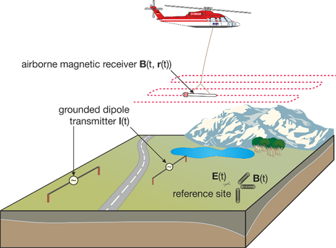
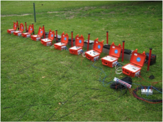
Conceptual surveying design of the semi-airborne EM method: An electrical dipole transmitter is installed on the ground and generates a powerful source signal; the induced EM field is recorded airborne during overflights.© Institut fuer Geophysik 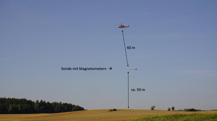
The BGR helicopter, towing the passive induction coil instrument in a field experiment near Schleiz, Thuringia.© Institut fuer Geophysik DESMEX II (2019-2023) broadens the scope of these developments and includes in addition developments of passive, natural source audio-frequency magnetic (AFMAG) measurements and drone-borne instruments. The objectives include to bring the developments closer to the market.
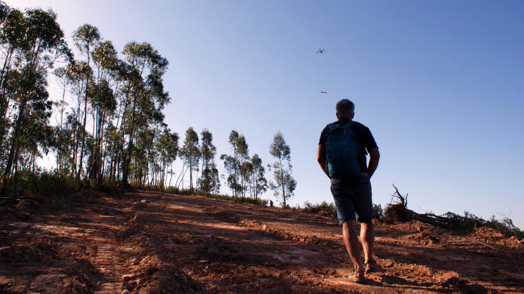
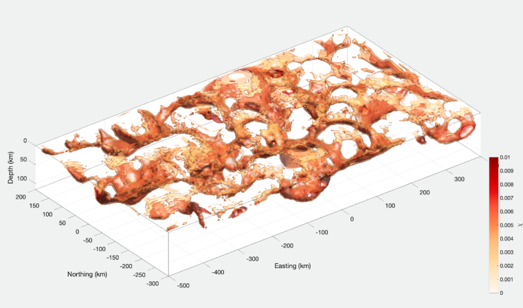
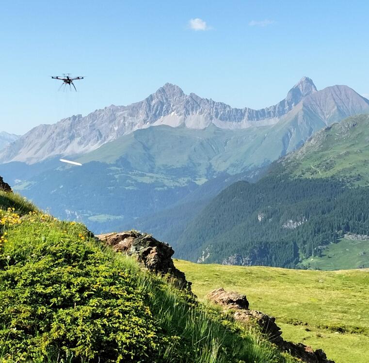
Drone with towed sensor during a measurement campaign near Aracena, Spain© Institut fuer Geophysik DESMEX-REAL (2022-2025) aims at demonstrating the DESMEX technologies on an industry-like scale. Core of the DESMEX-REAL project is the surveying of the entire upper Harz Mountain region with a sequence of semi-airborne EM surveys and to integrate the geophysical data and models with geological and petrological data and archive data from historical mining.
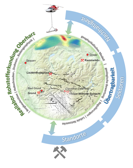
Large-scale investigations will be conducted in the Upper Harz Mountains historical mining district. © Institut fuer Geophysik DESMEX-MinD (starting in 2026) is a consortium project funded by the German Federal Ministry for Research, Technology and Space (BMFTR), aiming to address key challenges in mineral exploration programs. To achieve this, innovative exploration methods are being further developed and combined with modern exploration concepts in order to derive new models for prospective mining regions in Germany.
The project places particular emphasis on both technological and methodological advancements, as well as on the investigation of mineral systems in the Erzgebirge and the Harz Mountains.

Contact: Michael Becken, Lina Schumacher
Selected Publications:
Becken, M., Kotowski, P.O., Schmalzl, J., Symons, G., Brauch, K., 2022. Semi-Airborne Electromagnetic Exploration Using a Scalar Magnetometer Suspended below a Multicopter. First Break, 40(8), 37-46. https://doi.org/10.3997/1365-2397.fb2022064
Becken, M., Nittinger, C.G., Smirnova, M., Steuer, A., Martin, T., Petersen, H., Meyer, U., Mörbe, W., Yogeshwar, P., Tezkan, B., Matzander, U., Friedrichs, B., Rochlitz, R., Gunther, T., Schiffler, M. and Stolz, R. [2020]. DESMEX: A novel system development for semi-airborne electromagnetic exploration. Geophysics, 85, E253–E267, https://doi.org/10.1190/geo2019-0336.1
Kotowski, P.O., Becken, M., Thiede, A., Schmidt, V., Schmalzl, J., Ueding, S. and Klingen, S. [2022]. Evaluation of a Semi-Airborne Electromagnetic Survey Based on a Multicopter Aircraft System. Geo-sciences, 12, 26. https://doi.org/10.3390/geosciences12010026
Smirnova, M.V., Becken, M., Nittinger, C., Yogeshwar, P., Mörbe, W., Rochlitz, R., Steuer, A., Costabel, S. and Smirnov, M.Y. [2019]. DESMEX Working Group. A novel semiairborne frequency-domain controlled-source electromagnetic system: Three-dimensional inversion of semiairborne data from the flight experiment over an ancient mining area near Schleiz, Germany. Geophysics, 84, E281–E292. http://dx.doi.org/10.1190/geo2018-0659.1
Smirnova, M., Juhojuntti, N., Becken, M., Smirnov, M., and the DESMEX WG, [2020]. Exploring Kiruna Iron Ore fields with largescale, semi-airborne, controlled-source electromagnetics. First Break, 38(1), 35–40. https://doi.org/10.3997/1365-2397.fb2020070
Steuer, S., Smirnova, M., Becken, M., Schiffler, M., Gunther, T., Rochlitz, R., Yogeshwar, P., Mörbe, W., Siemon, B., Costabel, S., Preugschat, B., Ibs-von Seht, M., Zampa, L.S. and Muller, F. [2020]. Comparison of novel semi-airborne electromagnetic data with multi-scale geophysical, petrophysical and geological data from Schleiz, Germany, J. Appl. Geophys., 182, 104172, https://doi.org/10.1016/j.jappgeo.2020.104172
UNDERCOVER: Unified Novel Deep ExploRation for Critical Ore discoVERy
The EU’s ambitious goals as outlined in the Critical Raw Materials Act (CRMA), NetZero Industry Act and the European Green Deal will lead to an increase in critical raw material (CRM) demand. To meet the demand, the utilization of the deposits deeper in the bedrock needs research and development. Geological Survey of Finland (GTK) is coordinating EU Horizon Europe project that is creating a paradigm shift in the exploration of deep critical raw materials.
The UNDERCOVER research project aims to enhance the responsible supply of raw materials. The project's objectives include advancing deep mineral exploration technologies, stimulating research and development, and enabling their responsible exploitation by exploration and mining stakeholders within EU.
The project aims to develop deep CRM exploration. This will be done by transforming the mineral systems concept into the first viable strategy for systematically exploring CRM deposits hidden deeper in the bedrock. The project will develop and integrate novel geophysical technologies and methods that are both cost-effective and environmentally friendly.
Europe holds significant potential for CRMs, particularly in regions like the Fennoscandian Shield and the Iberian Pyrite Belt. Yet, after centuries of mining, shallow and easily accessible deposits are becoming less common. Therefore, we must also focus on deep deposits.
Traditional mineral exploration methods typically involve searching for anomalous signatures, such as anomalies in geochemical or airborne geophysical data, which are then verified through drilling. Despite having extensive empirical data for a given area, discovering deep deposits hidden deeper in the bedrock remains exceedingly rare. In this context, "deep" refers to depths ranging from a few hundred meters to over 1 kilometer below the Earth's surface.
Case studies in Finland (Kuusamo Schist Belt), Portugal (Iberian Pyrite Belt), and Namibia (Kalahari Copper Belt) will serve to the develop and integrate the technologies comprising the new strategy.The working group will be mainly involved in the airborne electromagnetic measurements as part of this project.
UNDERCOVER project receives funding from the European Union's Horizon Europe research and innovation programme under the grant agreement 101177528.
Contact:
Michael Becken,
Juha Kaija, Senior specialist, Project Manager, GTK Finland
GeoMetEr
Development of geophysical measurement procedures and combinations of methods for the creation of high-resolution surface exploration programmes
In the ‘GeoMetEr’ research project funded by the Bundesgesellschaft für Endlagerung (BGE), geophysical measurement methods for surface exploration programmes for the search for a repository for radioactive waste are to be further developed and tested in combination in two research regions in Germany. The working group is involved in the joint project by carrying out and analysing semi-airborne EM. An overview of the overall project, which is coordinated by LIAG Hannover, can be found on the project page.
Duration: 01.2023 - 03.2028
Contact: Michael Becken
Funding:

© BGE
Further projects
Archaeological prospection Amyklaion, Greece
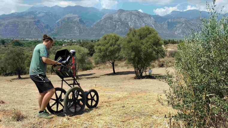
In cooperation with the Institute for Classical and Christian Archaeology of the WWU Münster and the Ionian University of Corfu, we are carrying out geophysical measurements to explore the Apollon Amyklaios sanctuary near Sparta ( https://amyklaion.gr/en/ ). The aim of the investigations is to identify further anthropogenic structures in the immediate vicinity of the already known sanctuary. To this end, the first measurements by means of geoelectrical tomography, georadar and magnetic field measurements were carried out in the summer of 2022.
This project is funded by the German Academic Exchange Service.
Contact: Volkmar Schmidt
© Institut fuer Geophysik Magnetotelluric Study of the Hangai Dome, Mongolia
Crust-mantle interactions beneath the Hangai Mountains in western Mongolia - Insights from 3-D magnetotelluric studies and 4-D thermo-mechanical modellingSurface deformation in the continental interior, away from active tectonic margins, is enigmatic, with the underlying mechanisms responsible not fully understood. Therefore, it is considered an open and important question in continental dynamics. The Hangai Dome, central Mongolia, is a natural laboratory to explore this question. It is a high elevation intra-continental region within the Mongolian plateau and the Central Asian Orogenic Belt. Of related interest, the Hangai region has a long history of volcanic activity, including Cenozoic episodes of intraplate volcanism, which occurred as recently as the Holocene. It is characterized by dispersed, low-volume, alkali basaltic volcanism. The processes and driving mechanisms responsible for generating intraplate magmatism remain largely unexplained. Furthermore, major fault systems, which have had several large magnitude (>7) intracontinental earthquakes within the last century, bound the Hangai region.
The project goals are 1. to collect high-resolution and multiscale magnetotelluric data, which measures variations of the natural electromagnetic fields, to image the electrical conductivity distribution throughout the crust and upper mantle beneath central Mongolia and 2. to integrate this with thermo-mechanical modelling, which can explore plausible geodynamic scenarios and the conditions under which they can occur, in order to better understand the mechanisms responsible for intracontinental uplift and intraplate volcanism in this unique region. Magnetotelluric data have been recorded across central Mongolia since 2016,
across the Hangai mountains, to the east, and to the south in the Gobi-Altai region, with plans to extend this coverage towards the north.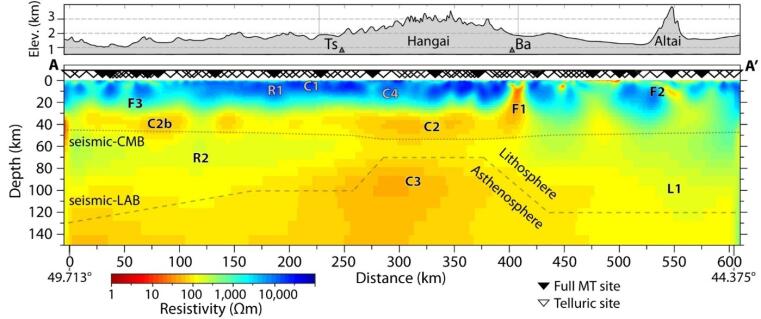
A resistivity model across the Hangai Dome shows what could be a hot mantle upwelling and shallowing of the asthenosphere-lithosphere boundary. Could this feature be related to the high surface topography and intraplate volcanism?© Institut fuer Geophysik Contact: Matthew Comeau, TU Delft
Publications and conference contributions:
Comeau, M. J., Becken, M., Kuvshinov, A. V., Demberel, S., Batmagnai, E., & Tserendug, S. (2021, November). Investigating the whole-lithosphere structure of a mineral system—Pathways and source of ore-forming fluids imaged with magnetotelluric modeling. In DEEP International Symposium on Deep Earth Exploration and Practices Extended abstract.
Comeau, M. J., Becken, M., Kuvshinov, A. V., & Demberel, S. (2021). Crustal architecture of a metallogenic belt and ophiolite belt: Implications for mineral genesis and emplacement from 3-D electrical resistivity models (Bayankhongor area, Mongolia). Earth, Planets and Space, 73(1), 1-20.
Comeau, M. J., Becken, M., Connolly, J. A., Grayver, A. V., & Kuvshinov, A. V. (2020). Compaction‐driven fluid localization as an explanation for lower crustal electrical conductors in an intracontinental setting. Geophysical Research Letters, 47(19), e2020GL088455.
Comeau, M. J., Becken, M., Käufl, J. S., Grayver, A. V., Kuvshinov, A. V., Tserendug, S., ... & Demberel, S. (2020). Evidence for terrane boundaries and suture zones across Southern Mongolia detected with a 2-dimensional magnetotelluric transect. Earth, Planets and Space, 72(1), 1-13.
Käufl, J. S., Grayver, A. V., Comeau, M. J., Kuvshinov, A. V., Becken, M., Kamm, J., ... & Demberel, S. (2020). Magnetotelluric multiscale 3-D inversion reveals crustal and upper mantle structure beneath the Hangai and Gobi-Altai region in Mongolia. Geophysical Journal International, 221(2), 1002-1028.
Comeau, M. J., Käufl, J. S., Becken, M., Kuvshinov, A., Grayver, A. V., Kamm, J., ... & Batmagnai, E. (2018). Evidence for fluid and melt generation in response to an asthenospheric upwelling beneath the Hangai Dome, Mongolia. Earth and Planetary Science Letters, 487, 201-209.
Completed projects
Elastic net constrained optimization for magnetic bottom depth estimation
We test elastic net inversion methods on heavily ill-posed problems such as geomagnetic inversion. Elastic net regularization can trade-off between equivalent sparse solutions with unphysical parameter values and smeared, smooth models which are difficult to interpret. An outcome of the inversion scheme is an estimate of the maximum depth of magnetization which we compare to classical spectral estimates.
3D inversion model of the magnetic susceptibility distribution using elastic net regularization. The model has voids (due to the sparsity constraint) and a maximum depth of magnetization that may indicate a temperature contour.© Institut fuer Geophysik Contact: Obinna Benedict Nwosu
Publications and conference contributions:
Nwosu, O. B., & Becken, M. (2022). Testing the use of elastic-net constrained optimization for magnetic bottom depth estimation. Poster presentation at the 100th DGG conference, Munich, Germany.
Drone-based montane archaeological prospection Oberhalbstein, Switzerland
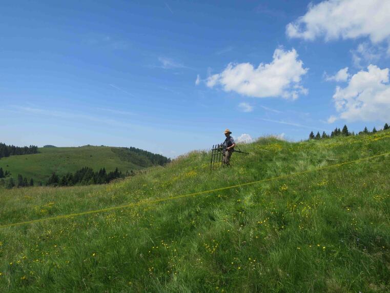
A wide range of raw materials have been extracted in the Alps for thousands of years. As early as the Bronze Age, the steadily growing demand for metal led to intensive copper ore mining, including in the Oberhalbstein region in Graubünden. Geomagnetic measurements will help to investigate the spatial structure of the mining area. Since magnetic measurements on the ground are difficult to carry out in the steep and marshy terrain, a drone was used for airborne measurements. Flying at low altitude in the alpine terrain is a particular challenge for taking measurements. This was only possible using an accurate elevation model, which was created by photogrammetric measurements. In June 2022, the first magnetic data were successfully obtained.
This project is funded by the German Mining Museum Bochum / Thyssen Foundation.
Contact: Volkmar Schmidt
© Institut fuer Geophysik Magnetic properties and magnetic anisotropy of salt rocks
The magnetic properties of rocks are of great interest in many fields of Earth sciences. One special field in rock magnetism is the measurement of the anisotropy of magnetic susceptibility (AMS) for detection of mineral alignment and rock deformation. Salt rocks are very weakly magnetic and measurement of the AMS is therefore complicated.
We investigate salt rocks from the Northern German Zechstein Basin and compare the magnetic properties with mineralogical composition. We have also found a significant AMS, which indicates mineral alignment. Further research is needed to understand the generation of the AMS by geological processes.
Contact: Volkmar Schmidt
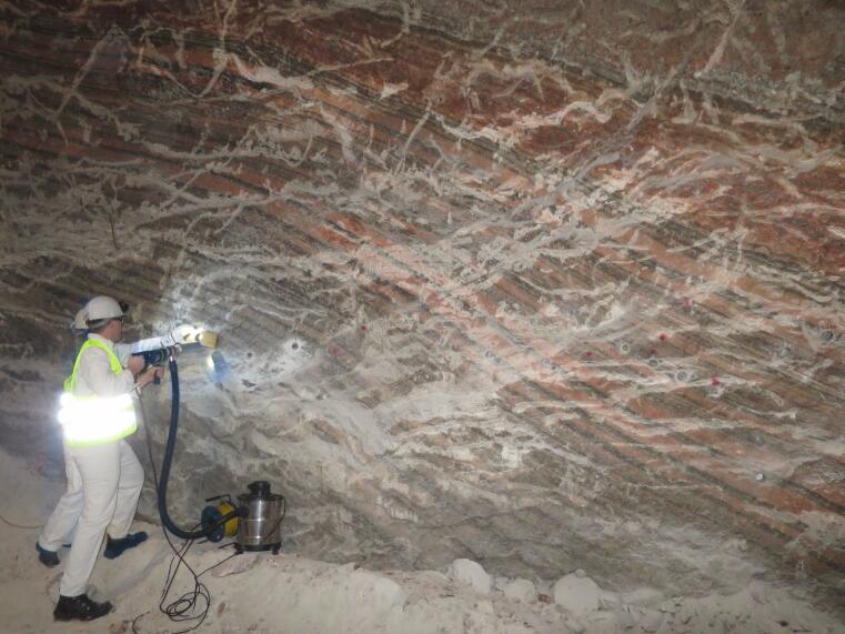
Taking Samples from a salt mine.© Institut fuer Geophysik Permittivity measurements of rocks
The permittivity is a physical property, which governs the propagation of electromagnetic fields. It is especially important for the propagation of radar waves, which have frequencies in the MHz-range. Radar waves are also used to image the subsurface, then the method is called ground penetrating radar (GPR). Whenever the GPR method is used to explore the subsurface, it is important to know the permittivity of the material. The permittivity can be measured in the laboratory, but data from small samples are often not transferable to natural rocks.
We have constructed a cylindrical measurement cell, which allows for the investigation of large rock samples. In combination with a vector network analyzer, the measurement system allows for rapid determination of spectral permittivity between 1 MHz and 500 MHz. For drill cores, spatial variations in permittivity can be resolved on a sub-centimeter scale.
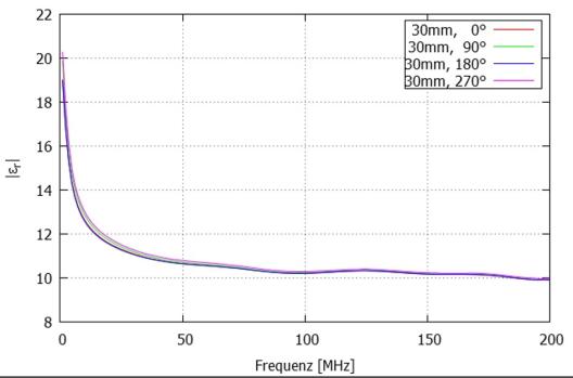
Absolute value oft he relative permittivity of a basalt sample.© Institut fuer Geophysik Contact: Volkmar Schmidt
Publications and conference contributions:
Pipeline-EM: Utilizing impressed current cathodic protection for EM Exploration
Central Europe is criss-crossed by pipelines to transport water, gas and oil. Metal pipelines are routinely protected against electrochemical corrosion with a coating supplemented with a cathodic protection system. For pipeline integrity tests, the DC current is temporarily switched on and off. The switching scheme effectively generates time-varying electrical currents and induces secondary electric and magnetic fields in the subsurface, which decay spatially and temporally as a function of subsurface electrical resistivity.
Here, we propose to measure and to analyze the induced electromagnetic fields generated by switched cathodic protection currents in order to determine the subsurface electrical resistivity structure in the upper few kilometers depth range. We concentrate on a test site in the Weserbergland, where we combine electric field array measurements of the induced electromagnetic field with detailed studies of the current distribution in the pipeline, i.e. the source current. Our cooperation partners from the Westnetz GmbH will provide results from pipeline integrity surveys conducted recently in the test area, as well as access to the technical installations of the cathodic protection system. In combination with additional DC electrical and magnetostatic measurements, this will allow us to determine the source current. For an interpretation of the array measurements, we will consider the transient time domain as well as the frequency domain response of the earth to the current injected into a pipeline structure and leaking inductively and, at grounding points and coating defects, galvanically into the ground.
This approach is closely related to controlled source electromagnetics, and may provide a cheap complement to existing electromagnetic geophysical sounding techniques, which is applicable in noisy environments without facing the logistical challenge of the installation a strong current source in the field. The methodology can aid in geophysical subsurface reconnaissance addressed in the exploration and monitoring of resources, reservoirs and geological storages.
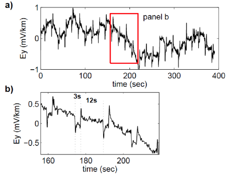
Ey-electric field component, recorded in the Wiehengebirge north of Osnabrück. a) Low-pass filtered time series at 128 Hz sampling rate, showing pulses superimposed on a varying background electric field. b) Zoom into the time series, showing pulse widths of 3 seconds and 12 seconds, respectively.© Institut fuer Geophysik Contact: Tobias Lindau
Publications and conference contributions:
Lindau, T. & Becken, M. (2014, August). Impressed pipeline currents for EM exploration. In: Proceedings of the 22nd EM Induction Workshop, Weimar, Germany.
Lindau, T., & Becken, M. (2014, March). First test measurements for utilizing Impressed Current Cathodic Protection of pipelines as a source for EM exploration. In: 74th DGG-Meeting, Karlsruhe, Germany.
Archaeo-geophysical explorations near Nonnweiler / Saarland
In the area of the municipality of Nonnweiler in the Hunsrück, about 30 km south-east of Trier, there are a number of interesting archaeological objects of both Celtic and Roman origin. Not far from the well-known Celtic ring rampart "Hunnenring", an ensemble of burial mounds of the Iron Age and presumably Roman period is known. Three groups of tumuli with 11 burials attest to the use of the settlement chamber since the 3rd century B.C. The presence of a local upper layer is attested by the discovery of a chariot grave.
In the run-up to and accompanying archaeological excavations in Nonnweiler, geophysical measurements are being carried out. The aim of these is to identify the most promising areas for excavation. In addition, these non-invasive methods can be used to make archaeological and geological structures visible over a larger area in the vicinity of the excavation. Magnetic methods are particularly suitable for imaging archaeological structures, but georadar and resistivity tomography can also be used to obtain additional information about the subsurface. Through in-situ measurements of the physical properties of the materials found in the survey area during excavation campaigns, we try to achieve a reliable evaluation and interpretation of the data.
A Celtic burial ground near Nonnweiler-Bierfeld could be localised with magnetic measurements. Excavations confirmed the location of the graves. Several nearby barrows are being investigated with geoelectrical measurements. Thus, the internal structure of the barrows can be concluded.
Contact: Volkmar Schmidt
Magnetic anomalies over Celtic burial ground. Linear structures show historical pathways.© Institut fuer Geophysik 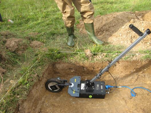
Georadar measurements on a planum.© Institut fuer Geophysik Towards imaging the Earth using EM fields emitted by DC railways
Direct current (DC) railways generate broadband electromagnetic noise fields that can impede the use of electromagnetic geophysics for subsurface investigations. Understanding (and controlling) the fields generated by DC railways could be a means to turn noise into signal and to use the noise fields for depth sounding and mapping. This project deals with (i) the development of an approximate railway electromagnetic source model based on synthetic model studies and field data, (ii) the adaption of time series processing schemes to the specific characteristics of train sources and (iii) the acquisition, processing, and modelling of field data near a railway line in a selected test area.
A pilot study was carried out in the Netherlands, which is criss-crossed by DC railway lines. At a test segment an electromagnetic receiver array was installed, and time series recordings were processed in frequency domain transfer functions using bi- and multivariate statistical processing schemes. It was found that the EM noise emissions from the railway line are highly correlated over 100s of square kilometers and that the source is approximately stationary - despite the fact that trains are moving sources. This implies that the primary source is due to current leakage at distinct points along the track (i.e. railway stations, railway crossings, bridges). Given this, a modelling and inversion approach was designed to iteratively determine both the source currents and the subsurface conductivity, similar to modelling schemes in global induction problems.
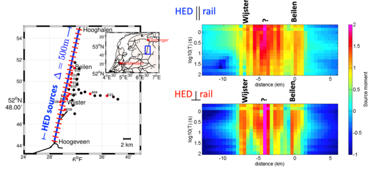
(left panel) Array of electric field receivers adjacent to a railway track. Inset shows the DC railway network in the Netherlands. (right panel) Estimated source moments of parallel and orthogonal electric point dipols along the test segment for a presumed earth conductivity from the first principal component of a multivariate analysis.© Institut fuer Geophysik This project was funded by Shell Global Solutions and carried out in cooperation with Rita Streich (Shell).
Contact: Anna Avdeeva, Michael Becken
Publications and conference contributions:
Becken, M., Avdeeva, A., & Streich, R. (2015). Are DC trains useful for electromagnetic exploration? In: Proceedings of the 26th Schmucker-Weidelt-Kolloquium, 21.-25. Sep. 2015, Dassel, Germany.
Avdeeva, A., Becken, M., & Streich, R. (2014, August). Towards imaging the Earth using EM fields emitted by DC railways. In: Proceedings of the 22nd EM Induction Workshop, Weimar, Germany.
EDE: Telluric recording system
Electromagnetic surveying in controlled and natural source applications can benefit from dense arrays of electric field recordings combined with more sparsely distributed five-component (electric and magnetic) stations. To facilitate such a surveying strategy, we have built a low-cost, low-power and easy-to-setup two-component data logger.
Photograph of the EDE systems during a parallel recording.© Institut fuer Geophysik Contact: Bernd Bömer
Publications and conference contributions:
Becken, M., Schmalzl, J., Bömer, B., & Ueding, S. (2014, August). Development of a E-field data logger and of time series processing tools in matlab. In: Proceedings of the 22nd EM Induction Workshop, Weimar, Germany.
Schmalzl, J., Lindau, T., Böhmer, B., Ueding, S., Becken, M. (2014, March). Development of an E-field data logger and first tests. In: 74th DGG-Meeting, Karlsruhe, Germany.
Archaeological prospection near Bucium / Romania
In the old mining district Bucium in the Transsylvanian ore mountains, many traces from Roman mining activities can be found, including remains of settlements, cemeteries, and roads. In cooperation with the German Mining Museum Bochum (Germany) and the Muzeul National al Unirii in Alba Iulia (Romania), we investigate the site using non-invasive geophysical methods. Many archaeological structures can be imaged using magnetic methods, since they generate anomalies in the magnetic field. We strive for a complete magnetic mapping of the area, which helps to reconstruct the layout of the mining area. We also use 2D and 3D electrical methods to image subsurface structures.
Contact: Volkmar Schmidt
Magnetic Mapping.© Institut fuer Geophysik