Subproject 200
SP 200 - Analysis and Monitoring of land cover and current land use change
Introduction - Objectives - Methods - Related publications

Introduction
 Research in the past years has boosted the opportunities for space applications addressing pressing environmental and agricultural issues. Significant work in the context of land-use-/land-cover mapping and monitoring has been carried out in the last years, e.g. under the GMES initiative of the European Union (www.gmes.info) and the international framework GEOSS (http://earthobservations.org/geoss.shtml). Long-term data archives and change detection methods (Mas 1999, Hofmann et al. 2008) become available for advanced use in comprehensive studies and applications”. GMES-related national R&D projects like DeCOVER (www.decover.info, Müterthies et al. 2009, Müterthies & Buck 2008) aim to contribute to the GMES-initiative and to serve the national user community. Within all the mentioned initiatives and projects core technologies for automatic image interpretation and change detection are under development, that can contribute to the objectives of the SASCHA-subproject “Analysis and Monitoring of land cover and current land-use change“.
Objectives
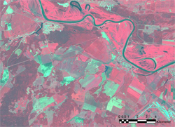
The SASCHA subproject ‘Analysis and Monitoring of Land Cover and current Land Use Change’ will develop, evaluate and implement a prototype system for the extraction of land use / land cover (LULC) information from remote sensing images. The system development will be driven by user needs collected from stakeholders of the Oblast´s Departments for Environmental Protection and Agriculture. As already identified by relevant European directives like INSPIRE (Infrastructure for Spatial Information in Europe), water-framework directive and NATURA 2000, land use and land cover datasets are an indispensible prerequisite for the support of stakeholders in environmental policy. One major issue in the context of the development of a sustainable land management system for the Tyumen Oblast therefore is the efficient collection of reliable up-to-date land-use and land-cover data for the complete territory of the Tyumen Oblast covering an area of 1.435.200 km². Optimised methods for land-use classification (e.g. Largouet & Cordier 2000) must be adapted to regional requirements. Due to the high rates of change of land use in the post-Soviet era as already observed in other parts of Russia (Hölzel et al. 2002), sustainability of the land use is strongly related to the availability of an efficient monitoring system, which allows a regular update of this data.
Methods
A core issue in the SASCHA-subproject “Analysis and Monitoring of land cover and current land use change” is the development of change detection methods and the implementation of adequate image analysis algorithms, especially for agricultural LULC changes such as the expansion and intensification of arable land. These algorithms should be able to differentiate agricultural land-use classes from natural and semi-natural land-use/land-cover classes.
The system adapts existing technologies from the Global Monitoring for Environment and Security (GMES) initiative to region-specific LULC classes and aims to enable a (semi‑)automatic detection and quantification of future LULC changes with a user-friendly and easy to use software interface.
Related publications
Hölzel N, Haub C, Ingelfinger MP, Otte A & Pilipenko VN (2002) The return of the steppe - Large-scale restoration of degraded land in southern Russia during the post-Soviet era. Journal for Nature Conservation 10: 75-86
Hofmann P; Lohmann P; Müller S (2008) Concepts of an object-based change detection process chain for GIS update: IntArchPhRS. Band XXXVII Teil B4. Peking, 2008: 305-312
Largouet C, Cordier MO (2000) Improving the Landcover Classification using Domain Knowledge, International Archives of Photogrammetry and Remote Sensing 33, Part B4: 538-545
Mas J-F (1999) Monitoring land-cover changes: a comparison of change detection techniques. International Journal of Remote Sensing. 20: 139-152
Müterthies A, Büscher O, Buck O (2009) Ergebnisse des nationalen Forschungsprojekts DeCOVER: Entwicklung eines Verfahrens zur Aktualisierung von Landbedeckungsdaten für öffentliche Aufgaben. In: Graef F, Bilo M & Hölzel N (eds.): Einsatz von Fernerkundung im Rahmen des FFH-Monitorings in Deutschland. BfN-Skripten 249: 96-104
Müterthies A. & Buck O (2008): DeCOVER - Optimised geoinformation services for land cover / use data to support decision makers in Germany. In: Maktav D & Musaoglu N (eds.): Remote Sensing for a Changing Europe. 28th EARSEL Symposium, Istanbul 2008: 64
Contact
Contact
Dr. Andreas Müterthies
EFTAS Fernerkundung Technologietransfer GmbH
Oststraße 2-18
D-48145 Münster
Tel.: +49 (0) 251 13307 0
Fax: +49 (0) 251 13307 33
E-Mail: info@eftas.com
Web: http://www.eftas.com/