
Projekt LIFE
| Projektbezeichnung | LIFE - Linked Data for eScience Services |
|---|---|
| Laufzeit | 01.01.2013 bis 30.06.2015 |
| Finanzierung | Gefördert durch die DFG |
| Partner | Institut für Geoinformatik |
| Ansprechpartner in der ULB | Holger Przibytzin E-Mail |
| Website | http://lodum.de/life |
Kurzbeschreibung:
LIFE ist eine Forschungsaktivität im Rahmen der Linked Open Data University of Münster (LODUM) Initiative zur Bereitstellung von Forschungs- und Lehrdaten als Linked Data.
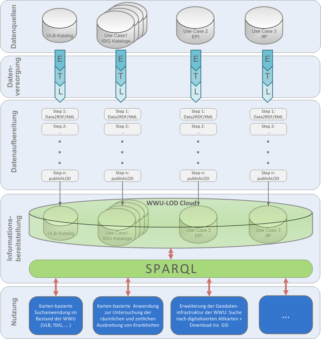
Ziel des LIFE-Projektes ist es, auf der Basis des Linked Data Ansatzes ein Lösungskonzept zur integrierten Bereitstellung vorhandener wissenschaftlicher Daten mit Raum- und Zeitbezug pilotartig (Proof of Concept) zu implementieren, um wissenschaftliche Fragestellungen besser oder überhaupt erst beantworten zu können (s. Abbildung links). Mit dem vorhanden technologischen Instrumentarium ist eine umfassende Datenintegration nicht zu leisten, Datensilos sind aktuell die Realität und die Nutzung vorhandener wissenschaftlicher Daten ist nur begrenzt möglich. Anhand von 3 Use Cases wird das geschaffene Instrumentarium möglichst praxisnah und gleichzeitig in der Breite evaluiert.
Das Potential des zu erprobenden Lösungsansatzes liegt darin, dass die Datenversorgung (Anbindung der unterschiedlichsten Datenquellen) mit relativ geringem Aufwand geleistet werden kann. Bestehende Systeme werden nur minimal angepasst, technisch wird mit spezialisierten ETL (extract–transform–load) Werkzeugen gearbeitet. Das Zielformat der Daten (RDF/XML) und deren Bereitstellung erfolgt nach dem technisch einfachen und etablierten Linked Open Data (LOD) Ansatz, die unterschiedlichen Schritte zur Datenaufbereitung werden mittels gängiger, standardkonformer Business Process Management (BPM) Werkzeuge organisiert und implementiert.
In der Konsequenz werden die heutigen Datensilos überwunden und alle eingebundenen Datenquellen können einheitlich (wie eine einzige Datenquelle) mittels LOD Techniken (SPARQL) angesprochen werden. Damit wird eine optimale Grundlage zur übergreifenden Nutzung wissenschaftlicher Daten geschaffen, die die Bearbeitung wissenschaftlicher Fragen in z.T. völlig neuen Kontexten ermöglicht. Dieser Sachverhalt ist für die Wissenschaft von unschätzbarem Wert.
LIFE ist daher als "Enabler"-Projekt zu sehen, in dem das Konzept erprobt und Werkzeuge entwickelt werden, um die Datenlage in den Bibliotheken und Fachbereichen auf neue, zeitgemäße Anwendungsfälle vorzubereiten.