
Prologue
The city of St. Wendel is set to kick off the Deutschland tour 2023 with a 2.2 km long prologue in its center. This town, situated in the state of Saarland, Germany, has a rich geological history that can be traced back to the Permian period.
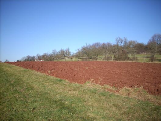
The entire town sits on a geological formation called the Rotliegend Group, which is made up of Permian-aged red sandstones and siltstones that are widely spread throughout the region. Both kinds of rock are abundant in iron oxide minerals, giving them an intense warm red hue, which is the reason for the name of the geologic formation (rot = red). The red colour of freshly plowed fields around the city testifies the Permian underground.
During the Permian period, approximately 300 million years ago, Germany was located in the subtropics of the supercontinent Pangea. The rocks of the Rotliegend were deposited under a hot and extremely dry climate. Catastrophic rainfall events occurred episodically during which high energy rivers formed.
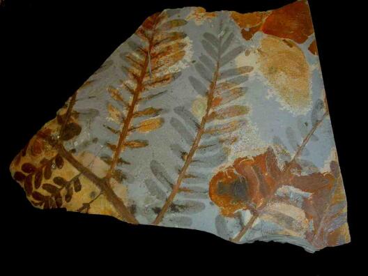
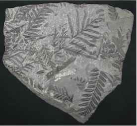
These rivers carried large amounts of sediment and created complex networks of channels and associated floodplains, which can be seen in the layers of sandstone today. While the Rotliegend Group is not particularly rich in fossils, there are some notable exceptions, including plant fossils such as ferns, horsetails and other primitive plants. These fossils provide valuable insights into the flora of the Permian period and help to reconstruct the paleoenvironment in which they were deposited.
Despite their prominence in the area, the red rocks from the Rotliegend are not typically used as a building material due to their relatively soft and porous nature. However, the St. Wendel region is home to a variety of other rock types that are commonly used in construction. One example is the Triassic Buntsandstein, a younger sandstone that overlies the Permian layers. This sandstone is more durable and weather-resistant than the Rotliegend and can be found in a variety of colors and textures. For this reason, it was used in important buildings like the Wendalinusbasilika, a stunning example of late Gothic architecture. Located in the city center, the basilica is constructed from several types of sandstone carefully selected for their durability, weather resistance and aesthetic qualities. The outside of the basilica is made of the most durable rock, while for the inside, the architects selected rocks of intense red tones, creating a peaceful, warm atmosphere. This unique architecture makes the Wendalinusbasilika the landmark of St. Wendel and invites pilgrims, cyclists and spectators of the Deutschland Tour to visit.

Located in the city center, the basilica is constructed from several types of sandstone carefully selected for their durability, weather resistance and aesthetic qualities. The outside of the basilica is made of the most durable rock, while for the inside, the architects selected rocks of intense red tones, creating a peaceful, warm atmosphere. This unique architecture makes the Wendalinusbasilika the landmark of St. Wendel and invites pilgrims, cyclists and spectators of the Deutschland Tour to visit.
Stage 1
Embarking on a thrilling cycling race from Sankt Wendel to Merzig, we are in for a geological treat during this first stage in line of the Deutschland Tour. This racing day promises not only an exhilarating challenge but also an exciting journey from fire-spitting volcanos to rock eating rivers.
Our tour begins in Sankt Wendel, where we pedal through the scenic countryside towards Freisen. Along this route, we encounter the first volcanic rocks of the Deutschland Tour. These volcanic rocks were formed from magma that rose to the surface during intense volcanic activity approximately 280 million years ago, during the Permian. The rising magma came from the Earth’s interior and easily made its way through fissures in the layers of the Rotliegend and flooded the surface of the back-then desert-like landscape. Once cooled, another lava flow emerged, so that the layers of volcanic rock became thicker and thicker. Today, these layers form a beautiful plateau of small mountains and hills reaching approx. 400 to 600 m elevation, including the former volcanoes.
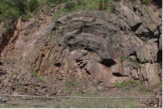
This landscape around Freisen also constitutes the highest point of this stage - perfect spot for the breakaway group to separate from the cyclists and look around for little gems. The exposed and eroded volcanic rocks are rich in a variety of minerals, in particular quartz and agate. Jasper, amethyst and carnelian can be found here as well. Exploration and treatment of these minerals gave rise to an important gemstone industry that flourished for centuries, especially in the area around Idar-Oberstein, which became (and still is) a hot-spot for gemstone processing and trade. Another highlight in Freisen is the so-called “Andesite Rose”, a 15-meter-high magmatic structure that resembles a halved onion. Wind and water worked their way along fine cracks and fissures that run concentrically inside the Andesite Rose, giving it its unusual look.
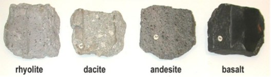
From Freisen, the riders make their way in the direction of the Bostalsee. On this road, they will encounter four different types of volcanic rock: rhyolite, dacite, andesite and basalt. The main difference between them is their amount of silica (SiO2): Rhyolite has the most, basalt has the least. Silica gives the rock a lighter grey tone, therefore you can see a nice gradient in color between rhyolite and basalt.
Once we arrive at Bostalsee, the lake invites us for a break, since the next spot we want to visit is in Mettlach, a town around 60 kilometers away from us. In between us and Mettlach lies a ride through an idyllic hillside, until we finally arrive at our last geologic spot: the Saarschleife.
This captivating geologic wonder is one of the most iconic landmarks in Germany and a testament of the geologic forces that shaped this region over millions of years. The river Saar makes a U-turn to flow around an elongated hill, the Burgberg, and this way creates a picturesque river bend that attracts visitors from all over the world.
The geological story of the Saarschleife begins with the sedimentary rocks that dominate the region. Between the Devonian (420 million years ago) and Triassic (250 million years ago), different layers of sediment were gradually deposited, compressed and covered with more sediment. Over hundreds of millions of years, the rock underneath Mettlach grew this way. The eroding power of the Saar came into play 23 million years ago, hence only recently – at least if you ask a geologist, who always has in mind the 4.5 billion years of earth’s history. At that time, which is the transition from Oligocene to Miocene, the Saar River flowed across a nearly flat land surface known as peneplain. It meandered through the geologic layers of the Triassic and Permian (see yesterday’s blog) and was situated about 300 meters higher than today. However, the river took only a few million years to dig itself through the old rock, until it reached the Taunus Quartzite which was formed during Devonian about 410 million years ago. When the Saar arrived at this layer in Pleistocene epoch, it met a hard and firmly cemented rock that was highly resistant to the river’s erosive forces. The disintegration of the ground was slowed down until the river found a joint in the rock that made it easier to move forward. Along this joint, the Saar River could eat its way through the Taunus Quartzite, giving it the unusual course that it follows till this day.
However, after all these impressions, we will cycle to Merzig, the destination of the first stage, and end our journey for today in one of the many restaurants in the tranquil town.
Stage 2
The second stage of the Deutschland Tour kicks off in the city of Kassel, located within the heart of the Hessen Depression (Hessische Senke in German). This elongated depression is nestled between the higher mountain ranges of the Harz in the north, and the Rhön and Vogelsberg in the south, the Rhenish Massif in the west and the Bohemian Massif in the east.
The Hessen Depression has been a relatively-low laying area for millions of years. Back in the Permian, some 255 million years ago, the Hessen Depression formed a shallow sea in between the Rhenish Massif and the Bohemian Massif. The so-called Zechstein Sea covered a substantial portion of what is now Central Europe, including parts of modern-day Germany, Poland, the Netherlands, and the United Kingdom. The Zechstein Sea was teeming with diverse marine life, including brachiopods, corals, ammonites, and various fish species. The sedimentation processes within the Zechstein Sea resulted in the formation of evaporite deposits, such as rock salt and potash, which are of great economic importance in the region.

The Permian was followed by the Triassic and Jurassic periods, which in Germany are marked by a sequence of distinct layers of sedimentary rock, each with its own unique characteristics. The lowermost unit is the Buntsandstein, characterized by red sandstones and conglomerates deposited in arid desert environments. Above it lies the Muschelkalk, a limestone formation rich in marine fossils, indicating the presence of a shallow tropical sea. Then comes the Keuper, consisting of claystones, marls, and sandstones, formed in a range of environments including lakes, rivers, and coastal areas. Finally, the Lias is particularly renowned for its-well preserved ammonites, belemnites and other marine invertebrates. This particular sequence of sedimentary rock (Zechstein, Buntsandstein, Muschelkalk, Keuper, Lias) is world-famous and is taught to geology students around the world.
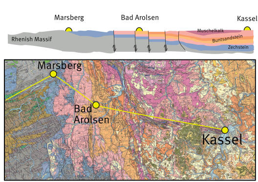
Because of the Hessen Depression has always been topographically low compared to the Rhenish and Bohemian Massif, this sequence of sedimentary rock has been recorded in the Hessische Senke. However, when we look at the cross section, the sequence is no longer a nicely-behaving layer cake. Several normal faults cross-cut the different layers, with the central part of the Depression moving down, and the rim moving up. This makes that the riders need to go up some kind of geological staircase when they ride from Kassel to Bad Arolsen and Marsberg. Kassel is on their lowest step and has the youngest layers (Muschelkalk and Buntsandstein). Every normal fault the riders concur, they encounter slightly older layers, until they reach the Hochsauerlandkreis, where they reach old sedimentary rock from the Carboniferous and the Devonian.
Continuing their ride, the cyclists now embark on a journey from Marsberg, to Brilon and Meschede. This stretch follows the axis of the Brilon anticline, a geological structure characterized by sedimentary rocks deposited during the Middle Devonian to Early Carboniferous periods. In other words, the riders step even further back in time, some 375 million years ago, when Germany was submerged beneath a shallow sea. In the heart of this submerged world, the Brilon Reef complex thrived. Think about a long-stretched reef, protecting a lagoon from wave energy. The reef was very successful during the Middle Devonian and accumulated more than a kilometer of limestone (German: Massenkalk). The Massenkalk was deposited in a shallow marine environment, where carbonate-producing organisms such as corals, stromatoporoids, brachiopods, bryozoans and crinoids thrived, leaving behind abundant fossils. However, as we ascend higher in the geological timeline, from the Middle Devonian into the Late Devonian, the growth of the Brilon Reef is dwindling. Interestingly, the decline of the Brilon Reef happened slightly earlier than the Late Devonian mass extinction, one of the “Big Five” mass extinctions in earth history, which affected reefs worldwide and signaled the end of a remarkable chapter in Earth's history.
In Meschede, the riders make a left turn, bidding farewell to the Brilon anticline, they venture into the adjacent anticline, which stands even higher and boasts older and harder Early Devonian rocks. These rocks, owing to their exceptional resistance to weathering and erosion, have withstood the test of time and now dominate the stage's topography, reaching its climax at Winterberg.
Stage 3
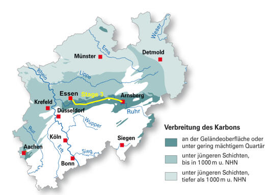
As the Deutschland Tour enters its third stage, the route from Arnsberg to Essen takes us along the picturesque flow of the river Ruhr. This west to east transect through the heart of North Rhine-Westphalia holds a remarkable geological story that is entirely shaped by the Carboniferous period.
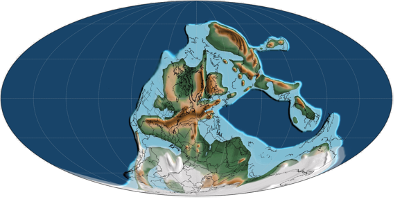
The Carboniferous period, which occurred roughly 358 to 299 million years ago, represents a chapter in Earth's history marked by fascinating geological and biological transformations. When we take a look at the position of the continents during that time, we see that the continents were dispersed across the globe at the beginning of the Carboniferous. Laurentia (now: North America and Western Europe) was situated near the equator, Gondwana (now: South America, Africa, Australia, India, and Antarctica) was located in the southern hemisphere, and Siberia was positioned in the northern latitudes. The tropical continent Laurentia was characterized by vast coastal plains, shallow inland seas, and a diverse array of plant and animal life. The humid climate of Laurentia supported the growth of lush forests and expansive swamps, setting the stage for the formation of significant coal deposits.
Throughout the Carboniferous, these disparate landmasses began to converge, driven by tectonic forces and the slow drift of continental plates. These gradual collisions of continents culminated in the formation of the supercontinent Pangaea. Pangaea was a vast expanse of interconnected land, stretching from pole to pole. Its formation had profound implications for climate patterns and the distribution of flora and fauna. The fusion of continents resulted in the formation of massive mountain ranges, such as the Appalachian Mountains in North America and the European Variscan Mountains (e.g., Brittany, Ardennes, Rhenish Massif, Vosges, Harz) in Europe.
As for life on our planet, the center of gravity shifts from the ocean in the Devonian to the continent in the Carboniferous. The Devonian, which we drove through yesterday on our way past Marsberg, Brilon, Meschede and Winterberg, is often called the time of the fish. The Carboniferous, on the other hand, is the age of coal-forming swamps, land-dwelling amphibians and giant insects. These swamps were home to a variety of plants, including ferns, seed ferns, and early trees. As these plants died and accumulated in the swampy environments, they underwent a slow process of decomposition and burial. Over millions of years, the intense pressure and heat transformed this organic matter into coal, resulting in the significant coal reserves found in North Rhine-Westphalia today.
The coal deposits that originated during the Carboniferous in North Rhine-Westphalia have played a crucial role in the region's development. Coal became a vital resource for industrialization, driving the growth of mining and heavy industries in the area. The rich coal reserves have contributed to the economic prosperity of North Rhine-Westphalia and shaped its cultural and social fabric. The Carboniferous coal mines along the Ruhr have all been closed over the last decades. Nevertheless, the exploration of younger, mostly Miocene, brown coal (lignite) in North Rhine-Westphalia has become a pressing subject of environmental concern. Lützerath, a village located in the Garzweiler coal mining area of North Rhine-Westphalia, became a focal point of environmental activism and protests against the expansion of open-pit coal mining. The RWE-operated lignite mine in the region threatened to engulf the village, leading to the displacement of residents and irreversible changes to the local ecosystem. The activists also raise concerns about carbon emissions and air pollution, fueled by calls for a shift towards renewable energy and a more sustainable future.
Stage 4
Welcome to the fourth stage of the Deutschland Tour, where we delve into the geology of Niedersachsen and Bremen. This stage takes us through the rural, mostly flat landscape of Northern Germany. While we’ll encounter only a few small obstacles with some elevation gain on our route, the processes that shaped these landscapes are far from boring.
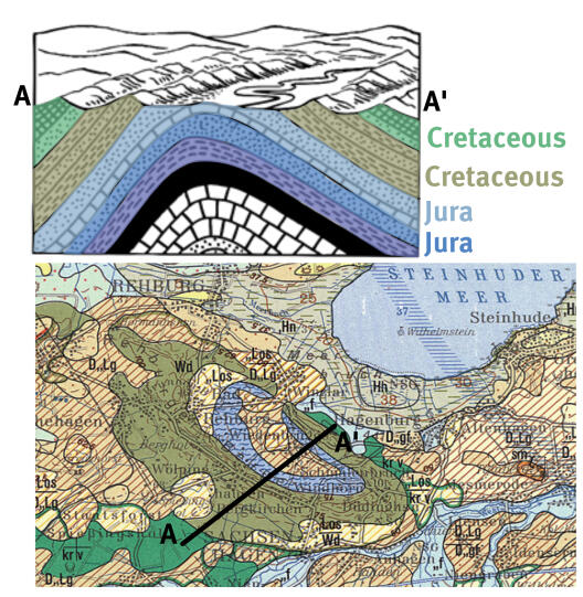
After the riders left Hannover, the journey begins with in the Rehburg Hills (German: Rehburger Berge), a small range of hills located in the northern part of Germany. From a geological perspective, the Rehburg hills represents a so-called anticline (German: Sattel). In an anticline, the layers of rocks are folded to form an arch-like or bulged shape. The bulging of the anticline can be attributed to the upward movement of salt deep underground. This underground salt movement exerted pressure on the layers of younger solid rock above it, causing them to be uplifted. Over time, the softer rocks at the core of the saddle, including clay and marl from the Upper Jurassic period (blue on the geologic map below), underwent weathering and erosion processes, leading to a morphological depression. So, what used to be the highest point of the anticline, now is a depression: That is what geologist call a relief inversion. The flanks of the saddle, composed of weather-resistant sandstones from the Lower Cretaceous period known as Wealden Sandstones, form the distinctive bowl-shaped ridge that characterizes the Rehburger Anticline.

As the riders continue their journey towards Bremen, they enter the vast expanse of the Northern German flat lands. This region is characterized by low-lying plains and is largely devoid of significant relief. The landscape gently undulates with nothing more than a few subtle rises and depressions, providing ideal conditions for high-speed cycling and a favorable terrain for sprinter teams. Just when it seems like the route will remain flat throughout, the riders face a minor challenge in Syke, where they encounter the "Hoher Berg." Don't let the name deceive you; the "Hoher Berg" translates to the "high mountain," but in reality, it reaches a modest height of 58 meters above sea level. The presence of this elevated point in an otherwise flat landscape can be attributed to past ice sheets and glaciers. They advanced and retreated through the landscape in a series of glacial and interglacial periods (ice ages). Over the last several million years, the alternating glacial and interglacial period governed Earth’s climate, much like a metronome with a beat of several ten thousands of years. The most recent cold period is called the Weichselian glaciation and occurred some 20,000 years ago. Back then, large parts of Mecklenburg-Vorpommern, Schleswig-Holstein, Berlin and Brandenburg were covered with ice. However, Bremen and Niedersachsen were largely spared. The penultimate Saalian glacial, however, was just a little bit colder and allowed the ice sheets to extend into Bremen and Niedersachsen (between 238 and 126 thousand years ago). But the ice did not come alone, the ice came with big amounts of large boulders and fine sediment. Most of Stage 4 takes the riders over so-called ground moraines of the Saalian glaciation. These are virtually flat blankets of till deposited underneath the glacier. They are mainly composed of clay, silt and sand. When the riders encounter the little topography in Syke, they reached the point where the glacier left behind coarser grained deposits of rocks, sediment and debris as they were receding. In other word, the “Hoher Berg” accumulated at the snout of the glacier some 126 thousand years ago.
In the end, whether it's relief inversion making hills look like bowls or glacial moraines making molehills seem like mountains, the geology of the Deutschland Tour reminds us that even in the realm of science, a touch of humor and absurdity can always find their place. So, keep pedaling, keep laughing, and let the geological wonders and whimsies continue to surprise us along this thrilling journey!