
Exhibition of old maps of Cyprus
30 May 1997, Münster
During the official inauguration ceremony of the Institute a collection of old maps of Cyprus (mainly from the 16th and 17th centuries) was exhibited in the historic castle of Münster. The maps belong to a private collection and were provided for this exhibition by the collector.
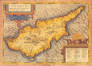
Map of Cyprus by Abraham Ortelius (1584)
In the meantime the collection has been published as volume 6 of the Institute's publication series.
Details