Subproject 300
SP 300 - Modelling of water and matter balances under global change
Introduction - Objectives - Methods - Results

Introduction
Climate and land use change affect the behaviour of hydrologic systems and result in alteration of the landscape water regime and water quality. As a consequence, conflicts about resources and interests between agriculture, nature- and water protection are to expect. Abandonment and protection as well as the agricultural intensification with following displacement of ecological systems such as fallows or peatland change hydrologic and ecological regimes on a large scale and on a long-term basis.
Ecohydrological models can represent catchment related processes as required for a sustainable integrated river management. Their applications allow realising temporally and spatially differentiated scenarios for management options. These models also help to assess the changes of the landscape water regime and nutrient budget.
Objectives
The objective of the study is the analysis and assessment of the regional water and matter balance. To fullfil this aim, the following subtargets are defined:
- Analysis of soil hydrology under different land use
- Analysis of water regime and nutrient budget in three selected river catchments
- Assessment of long-term impacts of land management
- Development of suitable indicators to address hydrological landscape functions and their ecosystem services
- Etablishment of sustainable integrated river management using climate and land use scenarios
Methods
For the analysis and assessment of the regional landscape water regime and nutrient budget we consider two scales: Plot scale and catchment scale. Three plots under forest, grassland and arable land as well as the three river catchments Pyschma, Vagai and Loktinka were selected.
In a first step, field investigations were conducted.
Plot scale:
- Determination of soil profiles and soil sampling for N and C analyses in different land use – soil combinations
- Measurements of soil water content and temperature under different land uses
- Measurements of seepage water for analysing N and C
Catchment scale (Vagai and Loktinka):
- Spatially distributed water quality analysis (temperature, oxygen, electrical conductivity, pH, NO3-, NH4-, TN, PO4-, C) along longitudinal river transects
- Measurement of water levels
In a second step two nested models were set-up and calibrated:
- Plot scale: CoupModel (Jansson & Karlberg 2004)
- Catchment scale: SWAT (Arnold et al. 1998)
Using these models, at first the current water and nutrient balance is simulated and later, climate and land use scenarios for the establishment of sustainable integrative river basin strategies are calculated.

Fig. 1: Schematic diagram
Results
Field campaigns were successfully carried out in 2012 and 2013 at three plots and in two catchments. The campaigns yielded the following results:
- In 2013, soil moisture under forest and grassland was higher than under arable land (Fig. 2). In April 2013 the soils under forest and grassland were still waterlogged. Water contents decreased in each horizon caused by evapotranspiration during the observed period.
- In summer 2012, there were high values of electrical conductivity - mostly >1000 µS/cm - found in the catchments streams (Vagai, Fig. 3). For nitrate and total nitrogen only light to moderate pollution was observed.
- Water quality components show a distinct difference before and after the snowmelt: In-situ measurements show higher conductivity and higher pH values before the snowmelt. Also all concentrations of nitrogen and phosphate are lower after the snowmelt (Fig. 4), due to dilution induced by snowmelt water. The concentrations in April/May 2013 are higher than the concentrations observed in June and July 2012. This indicates that the highest concentrations occur prior to the snowmelt and then probably gradually decrease.
- The carbon concentrations suggest an influence of the peatlands and wetlands.
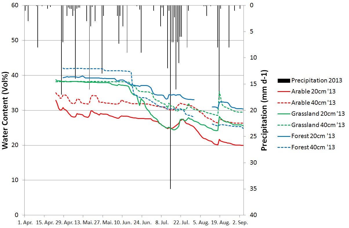
Fig. 2: Measured soil water content in different depths under forest, grassland and arable land use from April until September 2013 (weather data from rp5.ru).

Fig. 3: Measured electrical conductivity in the Vagai catchment in June 2012.
![Fig. 4: Measured total nitrogen concentrations [mg/l] in the Vagai catchment in April/May 2013 including land use (based on the classification of SP200). First numbers/gray columns show concentration before snowmelt, second numbers/black columns show concentration after snowmelt.](/SASCHA/imperia/md/images/sascha/teilprojekte/sp300/stickstoff.jpg)
Fig. 4: Measured total nitrogen concentrations [mg/l] in the Vagai catchment in April/May 2013 including land use (based on the classification of SP200). First numbers/gray columns show concentration before snowmelt, second numbers/black columns show concentration after snowmelt.
Furthermore, the models CoupModel (plot scale) and SWAT (basin scale) were setup and parametrised, calibrated and validated for the selected plots and catchments, respectively. Thus, water and nutrient balance can be simulated, and processes in these lowland areas can be analysed.
Results of the ecohydrological model SWAT show that the consideration of snow melt and retention of surface runoff as well as the implementation of a second groundwater aquifer was of great importance for a correct representation of the Siberian lowland hydrology.
Contact
Contact
Prof. Dr. Nicola Fohrer
Christian-Albrechts-Universität zu Kiel
Institut für Natur- und Ressourcenschutz
Abteilung für Hydrologie und Wasserwirtschaft
Olshausenstr. 75
24118 Kiel
Tel.: +49 (0) 431 880 1276
Fax: +49 (0) 431 880 4607
E-Mail: nfohrer@hydrology.uni-kiel.de
Web: http://www.hydrology.uni-kiel.de/